英国-道路交通データ

このデータセットは、英国全体の道路交通パターンの広範な概要を提供します。信頼性の高い交通監視システムから提供され、さまざまな地域の交通密度、平均速度、ピーク交通時間に関する詳細情報が含まれています。このデータは、交通計画、交通安全、都市開発の関係者にとって不可欠であり、英国の交通動態を詳細に理解するのに役立ちます。

英国の交通データに関する包括的な洞察

英国全土の交通および都市インフラ計画における情報に基づいた意思決定に不可欠な、渋滞レベル、ピーク移動時間、速度パターンなどの主要な交通指標を調べてください。

該当なし

Total Number of records
Sign Up for Free

59233 KM

英国の道路リンクの長さ
Sign Up for Free

28 キロ/時

ロンドンの平均速度
Sign Up for Free

ニュー・バーン・ロード-106.5km/h

ファステッド・ロード・バイ・メディアン・スピード
Sign Up for Free

英国の道路交通を垣間見る

都市計画立案者や交通当局にとって不可欠な、英国全土の交通動向と統計を示すデータセットの一部をご覧ください。

Key Variables

英国全土の交通および都市インフラ計画における情報に基づいた意思決定に不可欠な、渋滞レベル、ピーク移動時間、速度パターンなどの主要な交通指標を調べてください。

Name
Description
Type
Sequence
The order of road segments or data points, important for mapping routes and analyzing traffic flow sequences.
Integer
Sample Size
The number of data points or observations collected, critical for the reliability and accuracy of traffic analysis.
Integer
Standard Deviation speed
A measure of speed variability, indicating the consistency or fluctuation of traffic speeds.
Float
TravelTime Standard Deviation
Reflects the variability in travel time, highlighting potential delays and inconsistencies in journey durations.
Float
Median speed
The middle value of speed measurements, offering a representative speed of traffic under typical conditions.
Float
SpeedLimit
The maximum legally permitted speed on a road segment, crucial for safety and traffic flow analysis.
Integer
Average speed
The arithmetic mean of speed data, useful for understanding overall traffic flow on a road segment.
Float
Distance
The length of a road segment or route, key in calculating travel times and route planning.
Float
Time set
A specific time frame under consideration, important for analyzing traffic patterns at different times.
DateTime
SpeedLimit
The maximum legally permitted speed on a road segment, crucial for safety and traffic flow analysis.
Integer
Street Name
The official name of a road, essential for location identification and route navigation.
String
Frc
A classification system for roads, determining their hierarchy and role in overall traffic mobility.
Categorical

Use Cases

How can this dataset benefit you?

効果的なトラフィック管理

特に都市部の渋滞が激しい時期には、交通データを利用して交通信号の動的な管理と制御を行います。

都市インフラ開発

このデータセットを活用して、急速に成長している英国の都市における道路網の計画と強化、交通の流れの効果的な管理、渋滞の緩和に活用してください。

交通安全の改善

データを分析してリスクの高い交通区域を特定し、的を絞った安全対策を実施して交通事故を減らします。
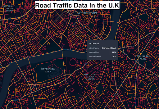
ロンドン道路速度データの視覚化

ロンドン全域の道路速度を包括的に視覚化したこのインサイトは、さまざまな道路の平均速度を示し、都市全体の交通の流れと速度パターンを明確に把握できます。このデータは、交通管理と都市計画戦略にとって重要です。

道路クラス別の平均速度

road_class

median_speed km/h

Motorways; Freeways; Major Roads

98.2

Major Roads less important than Motorways

63.2

Other Major Roads

36.3

Secondary Roads

34.1

Local Connecting Roads

33.9

Local Roads of High Importance

34.1

Local Roads

27.1

Local Roads of Minor Importance

12.3

速度が中央値の主要道路の例

streetName

medianSpeed

Saint Albans Road

30.1

Pettits Lane North

32.6

Gallows Corner Roundabout

33.15

Telford Road North Circular Road

33.4

Chigwell Road

34.8

Burford Bridge Roundabout

35

Hainault Road

36.6

Bowes Road

37.5

Givons Grove Roundabout

38

Brook Street Roundabout

40.7

A41

104.5

A1(M)

105

M23

106

New Barn Road

106.5

M40

107

M1

107

Sevenoaks Bypass

107

A21

109

M26

109

M20

111

英国の道路交通データ

主要高速道路から都市部まで、さまざまな道路の交通量、渋滞レベル、速度傾向に関する詳細情報が含まれています。この包括的な洞察は、国の交通計画、交通安全分析、地域の交通変動の理解に役立ちます。

各道路の交通量に関連するロンドンの道路網

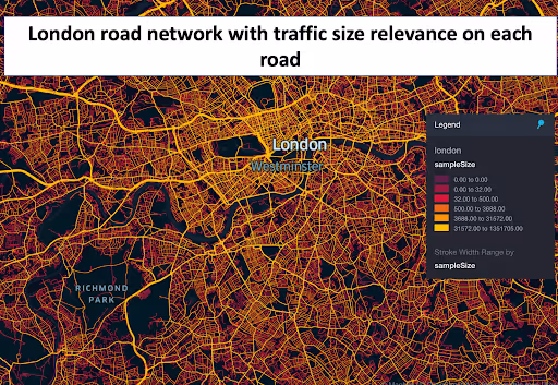
この洞察により、ロンドンの道路網の詳細がわかり、各道路の交通量が浮き彫りになります。これにより、都市全体の交通分布を明確に把握し、交通量の多い主要道路や潜在的な渋滞箇所を特定できます。

ウェストフィールド・ストラトフォード・シティの両側からの交通データ

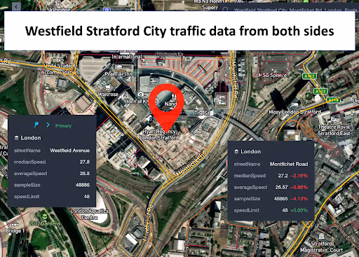
ウェストフィールド・ストラトフォード・シティの周辺地域に焦点を当てたこのデータインサイトは、ショッピングセンターへの両方のアプローチからの交通量と密度を明らかにしています。この繁華街の小売店やレジャー活動に関連する交通パターンを理解するには、このデータが不可欠です。
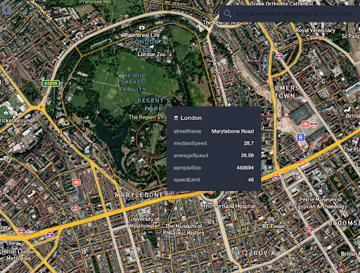
時速50kmを超えるロンドンの街並み

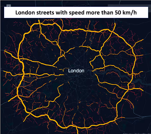
この分析により、交通速度が時速50kmを超えるロンドンの道路が特定され、市内の高速道路に関する洞察が得られます。交通安全評価や都市計画に特に役立ちます。

このデータはロケーションマインドが提供していますが、データソースは TomTom です。

Why xMap?

xMap empowers businesses with unparalleled location intelligence and comprehensive data analysis, guiding them towards market leadership and growth.

Close Faster

23

Times more likely to acquire customers
Sign Up for Free

Improve Sales

4.5%

Of the total revenue because of data-driven innovations
Sign Up for Free

Retain More

6

Times more likely to retain customers
Sign Up for Free

Frequently Asked Questions

Find answers to commonly asked questions about our spatial analyst platform.

データセットはどのくらいの頻度で更新されますか?

データセットは 3 か月ごとに更新され、食料品市場の動向における新規参入や閉鎖、変化が反映されます。

この交通量データはどのように役立ちますか?

トラフィック分析、中央速度、トレンド分析、予測などが該当します。

このデータを他の GIS ツールと統合できますか?

はい、私たちのデータセットは主要なGISプラットフォームと互換性があり、シームレスな統合と分析が可能です。

ムニーブ・レーマン
通常はすぐに返信します
ムニーブ・レーマン
こんにちは
今日はどうすればお手伝いできますか?
Whatsappチャットを開始する