ウクライナ-道路交通データ

にぎやかな大都市圏から穏やかな田舎道まで、ウクライナ全土の交通状況、渋滞レベル、交通安全に関する洞察を提供する詳細なデータセット。

ウクライナ全土の重要な交通情報

詳細な指標と分析を掘り下げて、ウクライナ全土の情報に基づいた交通計画と管理に不可欠な交通の流れ、渋滞のホットスポット、速度傾向の微妙な違いを明らかにしてください。

該当なし

Total Number of records
Sign Up for Free

169,694 キロメートル

ウクライナ道路の全長(Kms)
Sign Up for Free

С-86.4km/h

中央速度別最速道路
Sign Up for Free

T-10-27-28.2km/h

中央速度別の最も遅い道路
Sign Up for Free

ウクライナの道路交通のスナップショット

包括的な交通データを活用してウクライナの道路網をナビゲートおよび改善し、安全性と効率の向上を促進します。

Key Variables

詳細な指標と分析を掘り下げて、ウクライナ全土の情報に基づいた交通計画と管理に不可欠な交通の流れ、渋滞のホットスポット、速度傾向の微妙な違いを明らかにしてください。

Name
Description
Type
Sequence
The order of road segments or data points, important for mapping routes and analyzing traffic flow sequences.
Integer
Frc
A classification system for roads, determining their hierarchy and role in overall traffic mobility.
Categorical
Sample Size
The number of data points or observations collected, critical for the reliability and accuracy of traffic analysis.
Integer
Average speed
The arithmetic mean of speed data, useful for understanding overall traffic flow on a road segment.
Float
TravelTime Standard Deviation
Reflects the variability in travel time, highlighting potential delays and inconsistencies in journey durations.
Float
SpeedLimit
The maximum legally permitted speed on a road segment, crucial for safety and traffic flow analysis.
Integer
Standard Deviation speed
A measure of speed variability, indicating the consistency or fluctuation of traffic speeds.
Float
Time set
A specific time frame under consideration, important for analyzing traffic patterns at different times.
DateTime
Distance
The length of a road segment or route, key in calculating travel times and route planning.
Float
Median speed
The middle value of speed measurements, offering a representative speed of traffic under typical conditions.
Float
Street Name
The official name of a road, essential for location identification and route navigation.
String

Use Cases

How can this dataset benefit you?

都市交通の流れの合理化

交通データを活用して都市中心部の渋滞を緩和し、毎日の通勤の効率を高めましょう。

対象を絞った交通安全キャンペーン

データに基づいたインサイトを活用してリスクの高いゾーンを特定して対処することで、事故率を大幅に削減できます。

インフラ開発の優先順位付け

交通パターンと渋滞データの徹底的な分析に基づいて、インフラの改善を最も必要な箇所に集中させてください。

中央速度別のロードクラス

streetName medianSpeed
T-10-27 28.2
Героїв Дніпра вулиця 31.6
Сім’ї Кульженків вулиця 34.45
Теодора Драйзера вулиця 34.9
Харківська площа 38.1
E373 40.25
Полярна вулиця 43.15
Чернігівська площа 43.8
Миропільська вулиця 48.8
Братиславська вулиця 53.8
Малинська вулиця 71.05
Дніпровське шосе 73.2
Академіка Заболотного вулиця 73.3
E95 73.85
E40 75.5
Наддніпрянське шосе 78.95
Велика Кільцева дорога 80
Брест-Литовське шосе 80.7
Одеське шосе 83.45
Столичне шосе 86.4

高速道路から地方道路までの速度を分析し、インフラが交通の流れに与える影響を反映して、効率と渋滞箇所を強調します。

相互関係マトリックス

交通量、速度、事故の関係を視覚化し、改善の指針となるパターンに関する洞察を提供します。

ストリート名別の平均速度 (トップ 10 ストリート)

道路を速度別に一覧表示し、都市計画に不可欠な効率の高いエリアや混雑しているエリアを特定します。

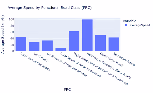
機能道路クラス (FRC) 別の平均速度

道路タイプ間で速度を比較し、インフラのパフォーマンスと計画のニーズを明らかにします。

このデータはロケーションマインドが提供していますが、データソースは TomTom です。

Why xMap?

xMap empowers businesses with unparalleled location intelligence and comprehensive data analysis, guiding them towards market leadership and growth.

Close Faster

23

Times more likely to acquire customers
Sign Up for Free

Improve Sales

4.5%

Of the total revenue because of data-driven innovations
Sign Up for Free

Retain More

6

Times more likely to retain customers
Sign Up for Free

Frequently Asked Questions

Find answers to commonly asked questions about our spatial analyst platform.

What types of data are included in the Road Traffic Insights?

This dataset encompasses real-time and historical data on traffic density, accidents, road conditions, and congestion trends.

この交通量データはどのように役立ちますか?

トラフィック分析、中央速度、トレンド分析、予測などが該当します。

How can this road traffic dataset benefit my business or project?

Leverage this dataset for site selection, analyze road traffic on your desired business location, enhanced route planning, strategic urban development projects, and to implement proactive traffic management strategies.

ムニーブ・レーマン
通常はすぐに返信します
ムニーブ・レーマン
こんにちは
今日はどうすればお手伝いできますか?
Whatsappチャットを開始する