マレーシア-道路交通データ

マレーシア全土の道路や高速道路をより安全で効率的なものにするために、交通に関する詳細な情報を調べてください。

マレーシア全域の重要な交通情報

詳細な指標と分析を掘り下げて、マレーシア全土の情報に基づいた交通計画と管理に不可欠な交通の流れ、渋滞のホットスポット、速度傾向の微妙な違いを明らかにしてください。

該当なし

Total Number of records
Sign Up for Free

238,823 キロメートル

マレーシア道路の全長 (Kms)
Sign Up for Free

Jalan Jambu 1-106km/h

中央速度別最速道路
Sign Up for Free

Jalan Melaka Raya 13-15.175km/h

中央速度別の最も遅い道路
Sign Up for Free

マレーシアの道路交通のスナップショット

マレーシアの道路交通の複雑さを明らかにするサンプルデータセットを調べて、情報に基づいた意思決定への道を開きましょう。

Key Variables

詳細な指標と分析を掘り下げて、マレーシア全土の情報に基づいた交通計画と管理に不可欠な交通の流れ、渋滞のホットスポット、速度傾向の微妙な違いを明らかにしてください。

Name
Description
Type
Sequence
The order of road segments or data points, important for mapping routes and analyzing traffic flow sequences.
Integer
Sample Size
The number of data points or observations collected, critical for the reliability and accuracy of traffic analysis.
Integer
Average speed
The arithmetic mean of speed data, useful for understanding overall traffic flow on a road segment.
Float
TravelTime Standard Deviation
Reflects the variability in travel time, highlighting potential delays and inconsistencies in journey durations.
Float
Standard Deviation speed
A measure of speed variability, indicating the consistency or fluctuation of traffic speeds.
Float
Distance
The length of a road segment or route, key in calculating travel times and route planning.
Float
Median speed
The middle value of speed measurements, offering a representative speed of traffic under typical conditions.
Float
Time set
A specific time frame under consideration, important for analyzing traffic patterns at different times.
DateTime
Frc
A classification system for roads, determining their hierarchy and role in overall traffic mobility.
Categorical
Street Name
The official name of a road, essential for location identification and route navigation.
String
SpeedLimit
The maximum legally permitted speed on a road segment, crucial for safety and traffic flow analysis.
Integer
SpeedLimit
The maximum legally permitted speed on a road segment, crucial for safety and traffic flow analysis.
Integer

Use Cases

How can this dataset benefit you?

都市渋滞緩和

交通データを適用して都市の混雑を緩和し、マレーシアの賑やかな都市での毎日の通勤時間を改善しましょう。

道路安全の強化

リスクの高い地域を特定し、的を絞った安全対策を講じて事故を減らし、人命を救います。

戦略的インフラ開発

包括的なトラフィック分析に基づいてインフラプロジェクトの優先順位を決め、リソースが効果的に割り当てられるようにします。

中央速度別のロードクラス

streetName medianSpeed
Jalan Melaka Raya 13 15.175
Lorong Pasar 15.35
Jalan PJS 11/7 17.7
Jalan Orkid 1 21.45
Jalan Gantam 21.45
Jalan Dr Krishnan 22.3
Lebuhraya Putrajaya-KLIA 91.1
Lebuhraya Pantai Timur 92.9
Lebuhraya Latar 94
Jalan Rimba Riang 9/12 99.5
Jalan Central Spine 99.6
Lebuhraya Utara Selatan 100
Lebuhraya Kajang Seremban 101
Lebuhraya Seremban-Port Dickson 103
E2 105.5
Jalan Jambu 1 106

マレーシアのさまざまな道路タイプの中央速度を調査し、高速道路と都市部および地方の道路の交通効率に関する洞察を明らかにしました。

相関マトリックス図

交通量、速度、時間、事故の関係を示す複雑な図で、パターンの特定や交通行動の予測に役立ちます。

ストリート名別の平均速度 (トップ 10 ストリート)

平均速度が最も高い道路と最も低い道路を一覧表示し、交通の流れと潜在的な渋滞エリアを垣間見ることができます。

ルブラヤ・ウタラ-セラタン道路の平均速度分布

この重要な南北高速道路沿いの速度変動を表示し、ピーク移動時間と渋滞ゾーンを強調表示します。

機能道路クラス (FRC) 別の平均速度

高速道路から一般道路まで、さまざまな機能道路クラスの速度を分析し、道路性能に関する洞察を提供します。

速度制限の分布

マレーシア全土の速度制限の範囲と分布を調査し、規制措置がさまざまな地域でどのように適用されているかを示します。

機能道路クラスの分布

マレーシアの道路網の構成を機能分類別に詳しく説明し、道路の種類とその目的の多様性を示しています。
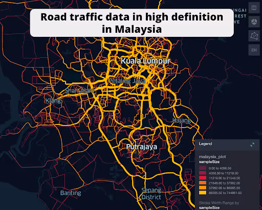
クアラルンプール道路ネットワークデータ

クアラルンプールの複雑な道路網を視覚化し、交通の流れ、渋滞のホットスポット、主要な交通ルートを強調します。

南北レブラヤ道路網データ

マレーシアの主要高速道路の交通パターンを詳細に示し、効率性を示し、渋滞が発生しやすい地域を特定します。
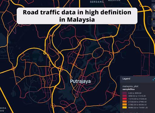
プトラジャヤ道路ネットワークデータ

プトラジャヤ内の道路網と交通管理戦略を紹介し、そのユニークな計画と交通の流れに焦点を当てています。

このデータはロケーションマインドが提供していますが、データソースは TomTom です。

Why xMap?

xMap empowers businesses with unparalleled location intelligence and comprehensive data analysis, guiding them towards market leadership and growth.

Close Faster

23

Times more likely to acquire customers
Sign Up for Free

Improve Sales

4.5%

Of the total revenue because of data-driven innovations
Sign Up for Free

Retain More

6

Times more likely to retain customers
Sign Up for Free

Frequently Asked Questions

Find answers to commonly asked questions about our spatial analyst platform.

この交通量データはどのように役立ちますか?

トラフィック分析、中央速度、トレンド分析、予測などが該当します。

What types of data are included in the Road Traffic Insights?

This dataset encompasses real-time and historical data on traffic density, accidents, road conditions, and congestion trends.

データセットはどのくらいの頻度で更新されますか?

データセットは 3 か月ごとに更新され、食料品市場の動向における新規参入や閉鎖、変化が反映されます。

ムニーブ・レーマン
通常はすぐに返信します
ムニーブ・レーマン
こんにちは
今日はどうすればお手伝いできますか?
Whatsappチャットを開始する