イタリア-道路交通データ

詳細な交通データを活用してイタリアの道路網をナビゲートおよび改善し、より安全で効率的な輸送を促進します。

イタリア全土の重要な交通情報

詳細な指標と分析を掘り下げて、イタリア全土の情報に基づいた交通計画と管理に不可欠な交通の流れ、渋滞のホットスポット、速度傾向の微妙な違いを明らかにしてください。

該当なし

Total Number of records
Sign Up for Free

487,700 km

イタリア道路の全長 (Kms)
Sign Up for Free

アウトストラーダデイラーギ-時速102km

中央速度別最速道路
Sign Up for Free

ヴィア・チルコンヴァッラツィオーネ・イドロスカロ-46.1 km/h

中央速度別の最も遅い道路
Sign Up for Free

イタリアの道路交通のスナップショット

イタリアが道路交通と都市モビリティを管理する方法に革命を起こす可能性を示す、厳選されたデータセットをご覧ください。

Key Variables

詳細な指標と分析を掘り下げて、イタリア全土の情報に基づいた交通計画と管理に不可欠な交通の流れ、渋滞のホットスポット、速度傾向の微妙な違いを明らかにしてください。

Name
Description
Type
Standard Deviation speed
A measure of speed variability, indicating the consistency or fluctuation of traffic speeds.
Float
TravelTime Standard Deviation
Reflects the variability in travel time, highlighting potential delays and inconsistencies in journey durations.
Float
Average speed
The arithmetic mean of speed data, useful for understanding overall traffic flow on a road segment.
Float
Sequence
The order of road segments or data points, important for mapping routes and analyzing traffic flow sequences.
Integer
Sample Size
The number of data points or observations collected, critical for the reliability and accuracy of traffic analysis.
Integer
Street Name
The official name of a road, essential for location identification and route navigation.
String
Median speed
The middle value of speed measurements, offering a representative speed of traffic under typical conditions.
Float
Frc
A classification system for roads, determining their hierarchy and role in overall traffic mobility.
Categorical
Distance
The length of a road segment or route, key in calculating travel times and route planning.
Float
Time set
A specific time frame under consideration, important for analyzing traffic patterns at different times.
DateTime
SpeedLimit
The maximum legally permitted speed on a road segment, crucial for safety and traffic flow analysis.
Integer

Use Cases

How can this dataset benefit you?

都市モビリティの最適化

高度な交通データを導入してイタリアの都市部の渋滞を緩和し、住民と訪問者の生活の質を高めましょう。

戦略的インフラ開発

強固なデータ分析でインフラプロジェクトに情報を提供し、重要なニーズに対応して道路効率を向上させる投資に優先順位を付けます。

交通安全対策の強化

データ主導型の安全イニシアチブで事故が発生しやすい地域を対象とし、リスクを大幅に軽減し、イタリア全土の道路利用者を保護します。

中央速度別のストリート名

streetName medianSpeed
Via Circonvallazione Idroscalo 46.1
Galleria Gracchi 57.6
Viale Brianza 62.2
E62 62.7
Strada Statale Paullese 63.6
Viadotto Parchi 64.9
Viale Enrico Forlanini 65.55
Via Rivoltana 67.35
SP415 70.8
Strada Provinciale Paullese 72.6
Strada Statale del Lago di Como e dello Spluga 89.6
Autostrada Milano-Brescia 90.6
Tangenziale Est 91
Autostrada dei Giovi 91.15
Strada Provinciale Rivoltana 92.7
Autostrada Torino-Milano 92.7
Via del Mare 93.25
Tangenziale Ovest 95.3
Autostrada del Sole 97.85
Autostrada dei Laghi 102

イタリアのさまざまな道路タイプの中央速度を分析し、高速道路と都市部の道路の効率性、および全体的な交通フローへの影響を強調します。

相互関係マトリックス

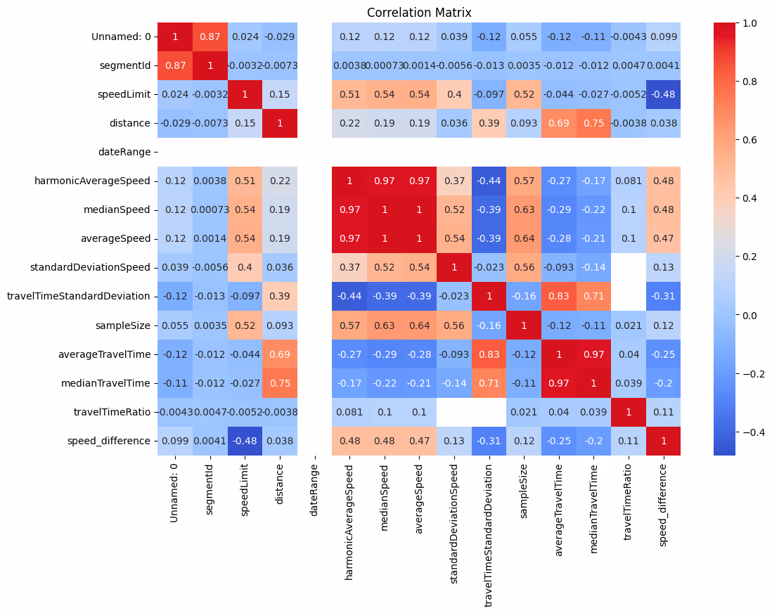
交通量、時間帯、道路タイプ、速度の関係を明らかにし、交通動態を多次元的に把握できます。

ストリート名別の平均速度 (トップ 10 ストリート)

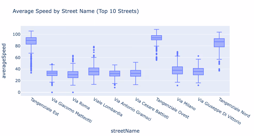
平均速度が最も高い道路と最も低い道路を識別し、渋滞しているエリアや流れがスムーズなエリアを示します。

タンジェンツィアーレ・オヴェスト・ロードの平均速度分布

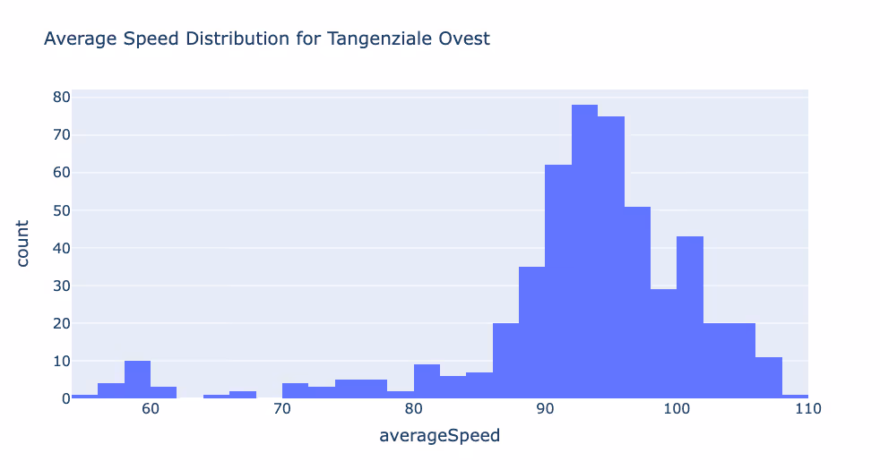
この重要なバイパス沿いの速度分布を詳しく示したグラフで、渋滞のピーク時間と交通の流れに関する洞察が得られます。

機能道路クラス (FRC) 別の平均速度

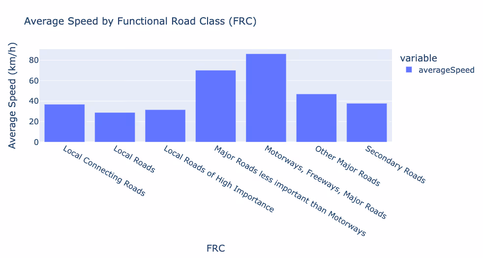
道路分類別に速度を分類し、高速道路、幹線道路、地方道路の違いを強調します。

速度制限の分布

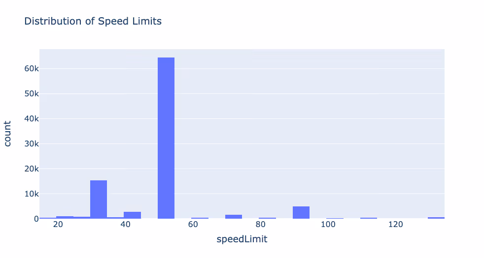
規制アプローチとそれが運転行動に与える影響を反映して、イタリア全土における制限速度の差異を図式化しています。

機能道路クラスの分布

イタリアの道路網構成の概要を説明し、高負荷道路と地方道路のバランスを強調しています。
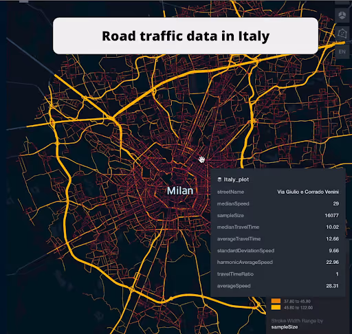
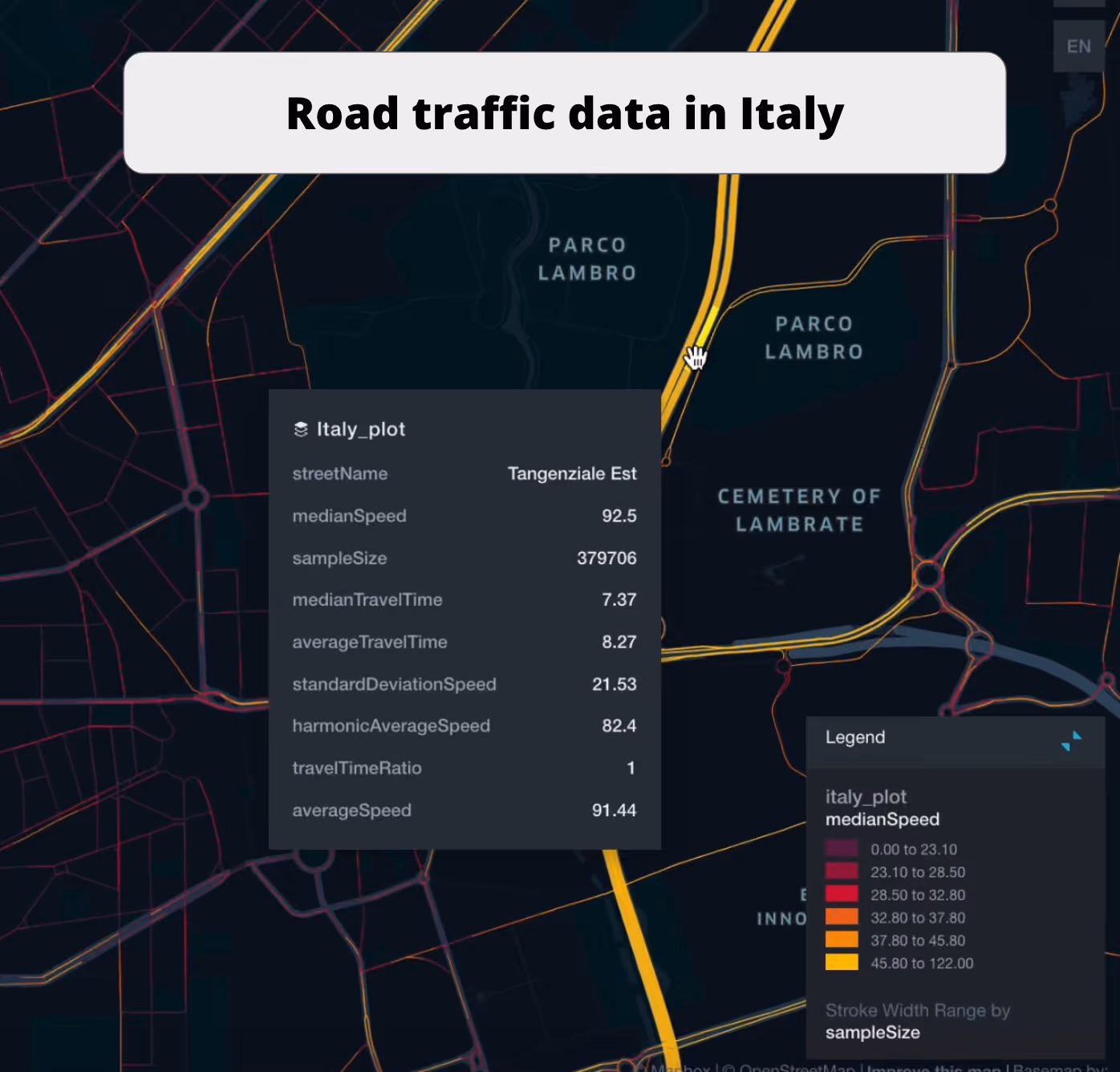
ミラノ交通データ

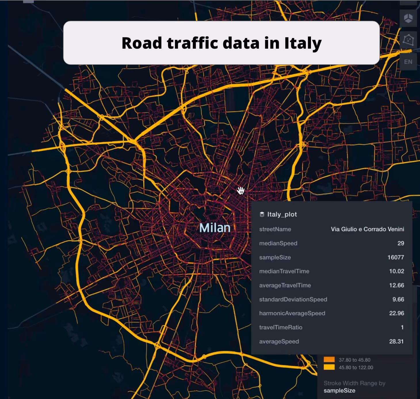
ミラノの交通状況を視覚的に分析し、渋滞パターン、交通のホットスポット、交通効率を示します。

タンジェンシアルウェスト道路ネットワークデータ

ミラノの主要バイパスの交通パターンを詳細に表示し、効率と問題のある領域を浮き彫りにします。

ヴィアーレ・ジャン・ガレアッツォ道路データ

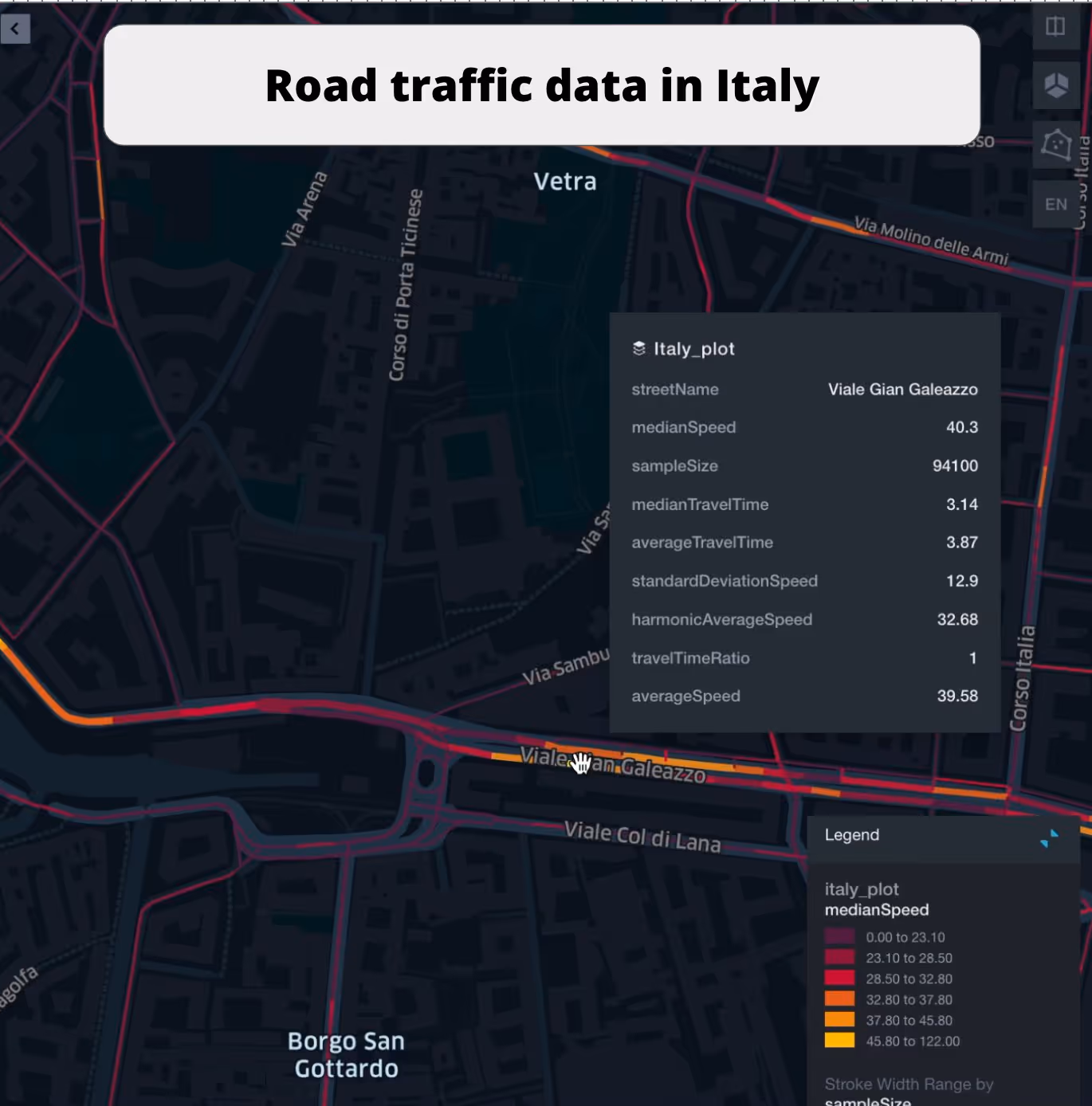
この重要な道路の交通の流れを視覚化し、速度の変化、交通量、潜在的な渋滞箇所を示します。

このデータはロケーションマインドが提供していますが、データソースは TomTom です。

Why xMap?

xMap empowers businesses with unparalleled location intelligence and comprehensive data analysis, guiding them towards market leadership and growth.

Close Faster

23

Times more likely to acquire customers
Sign Up for Free

Improve Sales

4.5%

Of the total revenue because of data-driven innovations
Sign Up for Free

Retain More

6

Times more likely to retain customers
Sign Up for Free

Frequently Asked Questions

Find answers to commonly asked questions about our spatial analyst platform.

この交通量データはどのように役立ちますか?

トラフィック分析、中央速度、トレンド分析、予測などが該当します。

What types of data are included in the Road Traffic Insights?

This dataset encompasses real-time and historical data on traffic density, accidents, road conditions, and congestion trends.

データセットはどのくらいの頻度で更新されますか?

データセットは 3 か月ごとに更新され、食料品市場の動向における新規参入や閉鎖、変化が反映されます。

ムニーブ・レーマン
通常はすぐに返信します
ムニーブ・レーマン
こんにちは
今日はどうすればお手伝いできますか?
Whatsappチャットを開始する