インドネシア-道路交通データ

豊富な交通データを調べて、インドネシア全土の交通安全を改善し、渋滞を緩和するための洞察を見つけましょう。

インドネシア全土の重要な交通情報

詳細な指標と分析を掘り下げて、インドネシア全土の情報に基づいた交通計画と管理に不可欠な交通の流れ、渋滞のホットスポット、速度傾向の微妙な違いを明らかにしてください。

該当なし

Total Number of records
Sign Up for Free

85万キロメートル

インドネシア道路の総長(Kms)
Sign Up for Free

日本トップチビタン-クリンシング | 91 km/h

中央速度別最速道路
Sign Up for Free

ジャラン・カプテン・スマントリ-11.25km/h

中央速度別の最も遅い道路
Sign Up for Free

インドネシアの道路交通のスナップショット

インドネシアの最も差し迫った交通課題に対する潜在的な解決策を紹介するデータセットをこっそり覗いてみましょう。

Key Variables

詳細な指標と分析を掘り下げて、インドネシア全土の情報に基づいた交通計画と管理に不可欠な交通の流れ、渋滞のホットスポット、速度傾向の微妙な違いを明らかにしてください。

Name
Description
Type
Sequence
The order of road segments or data points, important for mapping routes and analyzing traffic flow sequences.
Integer
TravelTime Standard Deviation
Reflects the variability in travel time, highlighting potential delays and inconsistencies in journey durations.
Float
Sample Size
The number of data points or observations collected, critical for the reliability and accuracy of traffic analysis.
Integer
Average speed
The arithmetic mean of speed data, useful for understanding overall traffic flow on a road segment.
Float
Standard Deviation speed
A measure of speed variability, indicating the consistency or fluctuation of traffic speeds.
Float
Street Name
The official name of a road, essential for location identification and route navigation.
String
Distance
The length of a road segment or route, key in calculating travel times and route planning.
Float
Time set
A specific time frame under consideration, important for analyzing traffic patterns at different times.
DateTime
Median speed
The middle value of speed measurements, offering a representative speed of traffic under typical conditions.
Float
Frc
A classification system for roads, determining their hierarchy and role in overall traffic mobility.
Categorical
Sequence
The order of road segments or data points, important for mapping routes and analyzing traffic flow sequences.
Integer
Sample Size
The number of data points or observations collected, critical for the reliability and accuracy of traffic analysis.
Integer
TravelTime Standard Deviation
Reflects the variability in travel time, highlighting potential delays and inconsistencies in journey durations.
Float
Average speed
The arithmetic mean of speed data, useful for understanding overall traffic flow on a road segment.
Float
Standard Deviation speed
A measure of speed variability, indicating the consistency or fluctuation of traffic speeds.
Float
Distance
The length of a road segment or route, key in calculating travel times and route planning.
Float
Time set
A specific time frame under consideration, important for analyzing traffic patterns at different times.
DateTime
Median speed
The middle value of speed measurements, offering a representative speed of traffic under typical conditions.
Float
SpeedLimit
The maximum legally permitted speed on a road segment, crucial for safety and traffic flow analysis.
Integer
Frc
A classification system for roads, determining their hierarchy and role in overall traffic mobility.
Categorical
Street Name
The official name of a road, essential for location identification and route navigation.
String

Use Cases

How can this dataset benefit you?

都市モビリティの強化

交通データを活用して、インドネシアのにぎやかな都市の都市交通の流れを合理化し、公共交通機関のルートを改善しましょう。

道路インフラ計画

データ主導型の洞察でインフラ開発に情報を提供し、接続性と安全性に関する重要なニーズに対応するプロジェクトに優先順位を付けます。

交通安全への取り組み

交通分析を通じて特定されたリスクの高い地域に的を絞った介入を実施し、全国の交通安全を大幅に改善します。
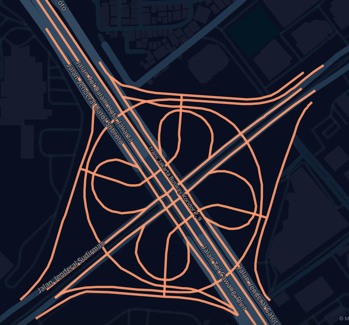
中央速度別のロードクラス

streetName medianSpeed
Jalan Kapten Sumantri 11.25
Komplek Pasar Induk Cibitung 13.55
Jalan Akses UI 14.85
Jalan Industri 16.8
Kodiklat Pusdikkes 17
Jalan Irigasi Pondok Ungu 18.25
Gang Marinah 18.55
Jalan Gedong 18.85
Jalan Tol Kelapa Gading - Pulo Gebang 79.1
Jalan Tol Akses Tanjung Priok 80.05
Jalan Tol Depok - Antasari 80.8
Jalan Tol Cengkareng - Batuceper - Kunciran 81.85
Jalan Tol Bocimi 84.3
Jalan Tol Bekasi-Cawang-Kampung Melayu 87.1
Jalan Layang MBZ Sheikh Mohamed Bin Zayed 87.1
Jalan Tol Cinere - Jagorawi 87.6
Jalan Tol Serpong - Kunciran 89.3
Jalan Tol Cibitung - Cilincing 91

高速道路から一般道路まで、インドネシアのさまざまな道路タイプにおける平均速度に関するインサイトで、効率性と潜在的な渋滞箇所を浮き彫りにします。

ジャラン・トール・ジャゴラウィの区間の制限速度遵守率は87.53%

速度制限に準拠しているセグメントのパーセンテージは 95.50%

ストリート名別の平均速度 (トップ 10 ストリート)

インドネシアで平均速度が最も高い道路と最も低い道路を特定し、都市交通の流れと渋滞管理に関する洞察を提供します。

ジャラン・トール・ジャゴラウィ道路の平均速度分布

この主要有料道路沿いの速度分布を示す詳細なグラフで、交通パターンと渋滞レベルに関する洞察が得られます。

機能道路クラス (FRC) 別の平均速度

道路の機能分類に基づいて平均速度を分類し、さまざまな道路網のパフォーマンスを明らかにします。
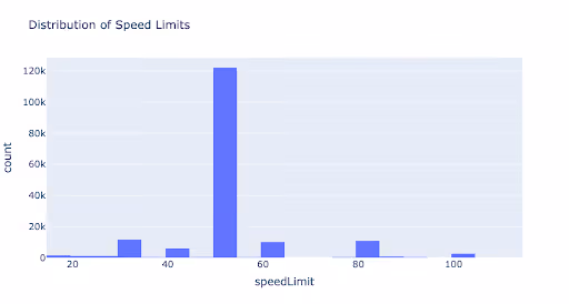
速度制限の分布

道路安全と交通管理に対する規制アプローチを反映して、インドネシア全土の制限速度の範囲と分布を分析します。

機能道路クラスの分布

高速道路から一般道路まで、インドネシアの道路タイプの多様性と分布、およびそれらが交通計画に与える影響の概要を示します。

このデータはロケーションマインドが提供していますが、データソースは TomTom です。

Why xMap?

xMap empowers businesses with unparalleled location intelligence and comprehensive data analysis, guiding them towards market leadership and growth.

Close Faster

23

Times more likely to acquire customers
Sign Up for Free

Improve Sales

4.5%

Of the total revenue because of data-driven innovations
Sign Up for Free

Retain More

6

Times more likely to retain customers
Sign Up for Free

Frequently Asked Questions

Find answers to commonly asked questions about our spatial analyst platform.

この交通量データはどのように役立ちますか?

トラフィック分析、中央速度、トレンド分析、予測などが該当します。

What types of data are included in the Road Traffic Insights?

This dataset encompasses real-time and historical data on traffic density, accidents, road conditions, and congestion trends.

データセットはどのくらいの頻度で更新されますか?

データセットは 3 か月ごとに更新され、食料品市場の動向における新規参入や閉鎖、変化が反映されます。

ムニーブ・レーマン
通常はすぐに返信します
ムニーブ・レーマン
こんにちは
今日はどうすればお手伝いできますか?
Whatsappチャットを開始する