カナダ-道路交通データ

きめ細かな交通データを活用して、カナダ全土のよりスマートな都市計画と効率的な交通管理を実現します。

カナダ全土の重要な交通情報

詳細な指標と分析を掘り下げて、カナダ全土の情報に基づいた交通計画と管理に不可欠な交通の流れ、渋滞のホットスポット、速度傾向の微妙な違いを明らかにしてください。

該当なし

Total Number of records
Sign Up for Free

1,042,300 キロメートル

カナダ道路の全長 (Kms)
Sign Up for Free

51km/h

平均速度
Sign Up for Free

ハイウェイ404-時速94.1キロ

中央速度別最速道路
Sign Up for Free

カナダの道路交通のスナップショット

当社の交通データ収集の深さと幅広さをプレビューして、きめ細かな洞察がいかにカナダの交通計画と管理に革命をもたらすかをご紹介します。

Key Variables

詳細な指標と分析を掘り下げて、カナダ全土の情報に基づいた交通計画と管理に不可欠な交通の流れ、渋滞のホットスポット、速度傾向の微妙な違いを明らかにしてください。

Name
Description
Type
TravelTime Standard Deviation
Reflects the variability in travel time, highlighting potential delays and inconsistencies in journey durations.
Float
Sequence
The order of road segments or data points, important for mapping routes and analyzing traffic flow sequences.
Integer
Sample Size
The number of data points or observations collected, critical for the reliability and accuracy of traffic analysis.
Integer
Street Name
The official name of a road, essential for location identification and route navigation.
String
Average speed
The arithmetic mean of speed data, useful for understanding overall traffic flow on a road segment.
Float
Standard Deviation speed
A measure of speed variability, indicating the consistency or fluctuation of traffic speeds.
Float
Distance
The length of a road segment or route, key in calculating travel times and route planning.
Float
SpeedLimit
The maximum legally permitted speed on a road segment, crucial for safety and traffic flow analysis.
Integer
Time set
A specific time frame under consideration, important for analyzing traffic patterns at different times.
DateTime
Frc
A classification system for roads, determining their hierarchy and role in overall traffic mobility.
Categorical
Median speed
The middle value of speed measurements, offering a representative speed of traffic under typical conditions.
Float

Use Cases

How can this dataset benefit you?

都市インフラ最適化

交通データを活用して、より効率的な道路を設計し、カナダの成長都市における渋滞を緩和します。

トラフィックフロー管理

リアルタイムのデータを適用して交通信号を調整し、渋滞を管理することで、カナダ全土での通勤体験を向上させます。

交通安全への取り組み

交通パターンを分析してリスクの高い地域を特定し、的を絞った安全対策を実施して、全国の交通安全を向上させます。

道路クラス別の平均速度

roadClass

medianSpeed

Motorways; Freeways; Major Roads

106

Major Roads less important than Motorways

52.3

Other Major Roads

58.3

Secondary Roads

50.1

Local Connecting Roads

50.6

Local Roads of High Importance

43

このインサイトでは、さまざまな種類の道路(高速道路、幹線道路、一般道路)がカナダの交通の流れにどのように影響するかを調査し、効率性と潜在的なボトルネックを明らかにしています。

中央速度別のロードクラス

streetName

medianSpeed

Eglinton Ave W

39.3

Eglinton Ave E

43.9

Highway 404 Collector

64.6

Gardiner Expy

81.25

Allen Rd

81.75

Don Valley Pky N

86.55

Don Valley Pky S

88.55

Gardiner Expy E

89.2

Hurontario St

91.25

Highway 404

94.1

さまざまな道路カテゴリで速度パターンがどのように出現するかを明らかにし、出発点としての道路分類に焦点を当てて、中央速度から逆の視点を示します。

相互関係マトリックス

速度、交通量、道路タイプなど、さまざまな交通変数がどのように相互作用するかを視覚的に分析し、交通動態に影響を与える重要な相関関係を特定します。

機能道路クラスの分布

道路の機能分類に基づいて道路の分布と特性を調べ、全国のインフラレイアウトを明らかにする。

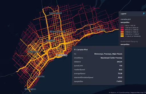
マクドナルドカルティエフリーウェイの全長は453635.12メートル

この主要高速道路の重要性を強調し、その長さとカナダの交通網における役割を詳しく説明します。

マクドナルドカルティエフリーウェイの平均速度分布

高速道路沿いの速度パターンを分析し、渋滞しているエリアや効率の高いエリアを特定します。

速度制限に準拠しているセグメントの割合は 72.79%

速度制限を掲示してコンプライアンス率について説明し、カナダの道路での運転行動と安全性に関する洞察を明らかにしています。

ストリート名別の平均速度 (トップ 10 ストリート)

交通状況と都市計画の有効性に関する洞察を提供しながら、平均速度の観点からトップストリートをリストアップして説明します。

道路セグメントの長さの分布

道路セグメントの長さがネットワーク全体でどのように変化するかを調べ、計画と接続性に関する洞察を提供します。

機能道路クラス (FRC) 別の平均サンプルサイズ

道路クラスごとに収集されたデータ量を調べ、交通情報の堅牢性を強調します。

マクドナルドカルティエフリーウェイデータ

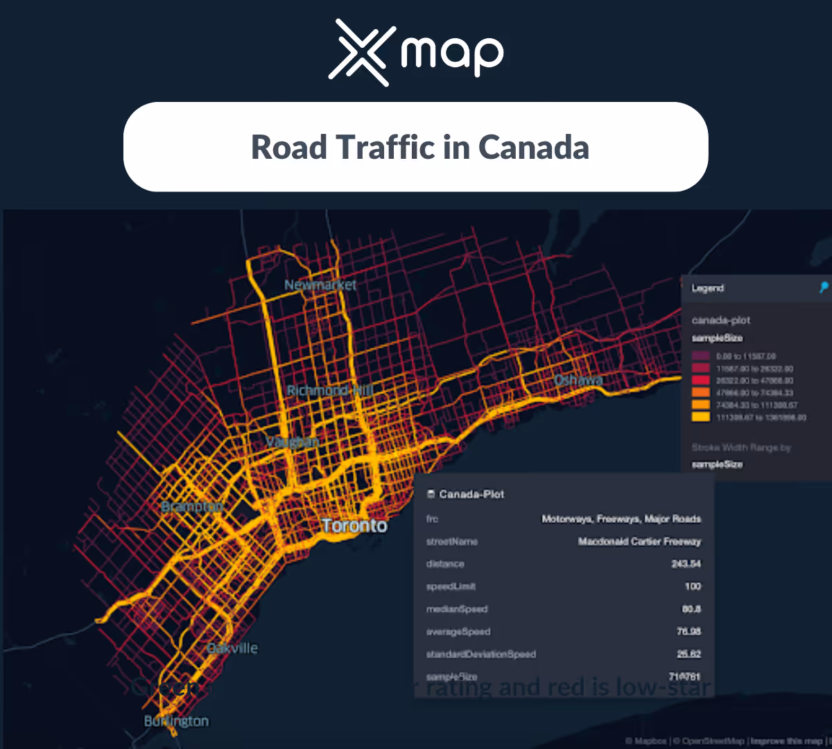
高速道路の交通データを視覚的に表現し、速度、交通量、渋滞を視覚的に示します。
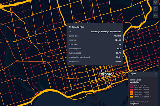
アレンロードデータ

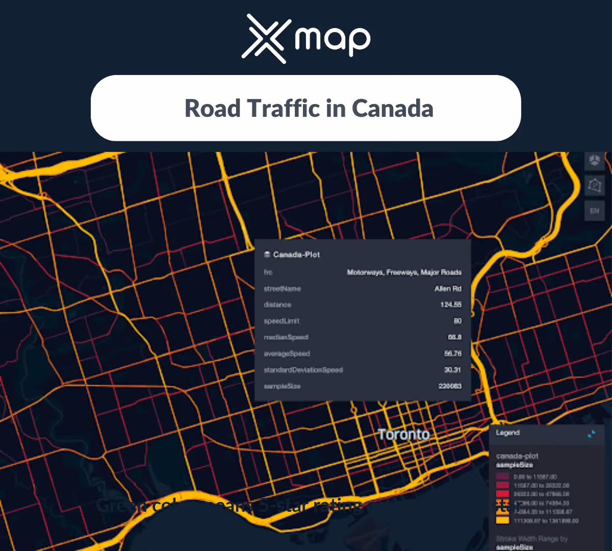
速度や渋滞などの主要な指標に焦点を当てて、アレンロードの交通パターンを詳細にグラフィカルに分析します。

このデータはロケーションマインドが提供していますが、データソースは TomTom です。

Why xMap?

xMap empowers businesses with unparalleled location intelligence and comprehensive data analysis, guiding them towards market leadership and growth.

Close Faster

23

Times more likely to acquire customers
Sign Up for Free

Improve Sales

4.5%

Of the total revenue because of data-driven innovations
Sign Up for Free

Retain More

6

Times more likely to retain customers
Sign Up for Free

Frequently Asked Questions

Find answers to commonly asked questions about our spatial analyst platform.

この交通量データはどのように役立ちますか?

トラフィック分析、中央速度、トレンド分析、予測などが該当します。

データセットはどのくらいの頻度で更新されますか?

四半期ごとにデータを更新し、最新の情報にアクセスできるようにしています。

What types of data are included in the Road Traffic Insights?

This dataset encompasses real-time and historical data on traffic density, accidents, road conditions, and congestion trends.

ムニーブ・レーマン
通常はすぐに返信します
ムニーブ・レーマン
こんにちは
今日はどうすればお手伝いできますか?
Whatsappチャットを開始する