ブラジル-道路交通データ

詳細な交通データを調べて、交通安全を強化し、交通管理を最適化し、ブラジル全土の持続可能な都市計画を支援してください。

ブラジル全土の重要な交通情報

詳細な指標と分析を掘り下げて、ブラジル全土の情報に基づいた交通計画と管理に不可欠な交通の流れ、渋滞のホットスポット、速度傾向の微妙な違いを明らかにしてください。

該当なし

Total Number of records
Sign Up for Free

200万キロメートル

ブラジルの道路の総長(Kms)
Sign Up for Free

エストラーダミュニシパル-401542.46 メートル

ブラジル最長の道路
Sign Up for Free

61.24 キロ/時

平均平均速度
Sign Up for Free

ブラジルの道路交通のスナップショット

ブラジルの道路ネットワーク管理を変革する可能性を示す、豊富なデータセットをのぞいてみましょう。

Key Variables

詳細な指標と分析を掘り下げて、ブラジル全土の情報に基づいた交通計画と管理に不可欠な交通の流れ、渋滞のホットスポット、速度傾向の微妙な違いを明らかにしてください。

Name
Description
Type
TravelTime Standard Deviation
Reflects the variability in travel time, highlighting potential delays and inconsistencies in journey durations.
Float
Sample Size
The number of data points or observations collected, critical for the reliability and accuracy of traffic analysis.
Integer
Sequence
The order of road segments or data points, important for mapping routes and analyzing traffic flow sequences.
Integer
Average speed
The arithmetic mean of speed data, useful for understanding overall traffic flow on a road segment.
Float
Standard Deviation speed
A measure of speed variability, indicating the consistency or fluctuation of traffic speeds.
Float
Median speed
The middle value of speed measurements, offering a representative speed of traffic under typical conditions.
Float
Street Name
The official name of a road, essential for location identification and route navigation.
String
Frc
A classification system for roads, determining their hierarchy and role in overall traffic mobility.
Categorical
Time set
A specific time frame under consideration, important for analyzing traffic patterns at different times.
DateTime
SpeedLimit
The maximum legally permitted speed on a road segment, crucial for safety and traffic flow analysis.
Integer
Distance
The length of a road segment or route, key in calculating travel times and route planning.
Float

Use Cases

How can this dataset benefit you?

最適化されたトラフィック管理

リアルタイムのデータを活用して、ブラジルのにぎやかな都市の交通の流れを合理化し、混雑を緩和します。

インフラ開発

ブラジル特有の地理的課題に適した、強靭で効率的な道路インフラの開発に関する情報を提供します。

道路安全の強化

交通情報を活用してリスクの高い地域を特定し、的を絞った介入を実施することで、すべての道路利用者の安全性を高めます。

中央速度別のロードクラス

streetName medianSpeed
Viaduto General Milton Tavares de Souza 15.7
Rua João Afonso 31.45
Rua José Félix 32.7
Praça Ari da Rocha 34.65
Rua Carmópolis de Minas 35
Avenida Aírton Pretini 35.15
Avenida Eusébio Matoso 35.9
Avenida Miguel Catarino 36.5
Avenida Professor Luiz Ignácio Anhaia Mello 36.7
Rodovia Perito Criminal Engenheiro Antonio Car... 87.8
Rodovia Presidente Dutra 88.7
SP-150 89.2
Acesso à SP-070 BR-116 89.25
Rodovia dos Imigrantes 89.6
Rodoanel Mário Covas 90.4
Rodovia Dom Pedro I 92.8
Rodovia Ayrton Senna da Silva 94
Rodovia dos Bandeirantes 104
Rodovia Governador Carvalho Pinto 109

ブラジル全土のさまざまな道路タイプが平均走行速度にどのように影響するかを調べ、道路効率とインフラ改善の余地のある分野に関する洞察を明らかにしています。
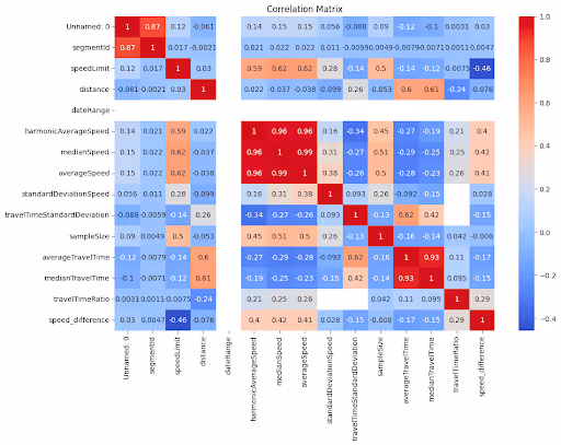
相関マトリックス図

速度、量、時間帯など、さまざまなトラフィック変数間の関係を視覚的に表現し、トラフィックダイナミクスの包括的な概要を示します。

エストラーダ市道の平均速度分布

Estrada Municipal沿いの速度分布を示す詳細なグラフを分析すると、交通の流れに関する洞察が得られ、渋滞のピーク時間を特定できます。

ストリート名別の平均速度 (トップ 10 ストリート)

都市環境で効率の高いエリアや混雑しているエリアを示し、平均速度から最も速い道路と最も遅い道路を特定します。

機能道路クラス (FRC) 別の平均速度

平均速度を道路分類ごとに分類し、さまざまなタイプの道路が全体的な交通状況にどのように影響するかを明らかにします。

エストラーダ・ミュニシパルの区間の制限速度遵守率は84.18%
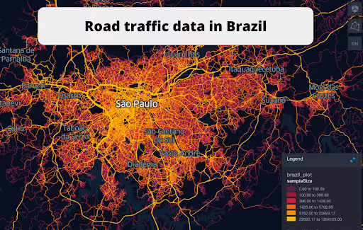
サンパウロ道路ネットワークデータ

サンパウロの道路網の概要をグラフィカルに表示し、交通パターン、渋滞のホットスポット、交通効率を示しています。

アベニーダデナソエスウニダス交通データ

アベニーダ・デ・ナソエス・ウニダスの交通状況を視覚的に把握し、交通量、速度傾向、ピーク渋滞時間を確認できます。

サンパウロ道路網衛星ビューデータ

衛星画像と交通データオーバーレイを組み合わせて、サンパウロの交通管理と都市計画戦略について独自の視点を提供します。

このデータはロケーションマインドが提供していますが、データソースは TomTom です。

Why xMap?

xMap empowers businesses with unparalleled location intelligence and comprehensive data analysis, guiding them towards market leadership and growth.

Close Faster

23

Times more likely to acquire customers
Sign Up for Free

Improve Sales

4.5%

Of the total revenue because of data-driven innovations
Sign Up for Free

Retain More

6

Times more likely to retain customers
Sign Up for Free

Frequently Asked Questions

Find answers to commonly asked questions about our spatial analyst platform.

この交通量データはどのように役立ちますか?

トラフィック分析、中央速度、トレンド分析、予測などが該当します。

What types of data are included in the Road Traffic Insights?

This dataset encompasses real-time and historical data on traffic density, accidents, road conditions, and congestion trends.

データセットはどのくらいの頻度で更新されますか?

データセットは 3 か月ごとに更新され、食料品市場の動向における新規参入や閉鎖、変化が反映されます。

ムニーブ・レーマン
通常はすぐに返信します
ムニーブ・レーマン
こんにちは
今日はどうすればお手伝いできますか?
Whatsappチャットを開始する