オーストラリア-道路交通データ

オーストラリア全土の道路利用状況、渋滞、交通量の複雑なパターンを明らかにする比類のないデータセットをご覧ください。国の道路の動向を捉えたデータで戦略的意思決定を行いましょう。

オーストラリア全土の重要な交通情報

詳細な指標と分析を掘り下げて、オーストラリア全土の情報に基づいた交通計画と管理に不可欠な交通の流れ、渋滞のホットスポット、速度傾向の微妙な違いを明らかにしてください。

該当なし

Total Number of records
Sign Up for Free

873,573 キロメートル

オーストラリア道路の総長 (Kms)
Sign Up for Free

コールダーフリーウェイエンド-98.5km/h

中央速度別最速道路
Sign Up for Free

40-14km/h

中央速度別の最も遅い道路
Sign Up for Free

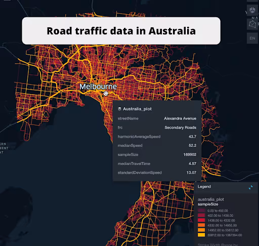
オーストラリアの道路交通のスナップショット

当社の交通データ収集の奥深さと幅広さをプレビューして、きめ細かな洞察がいかにオーストラリアの交通計画と管理に革命をもたらすかをご紹介します。

Key Variables

詳細な指標と分析を掘り下げて、オーストラリア全土の情報に基づいた交通計画と管理に不可欠な交通の流れ、渋滞のホットスポット、速度傾向の微妙な違いを明らかにしてください。

Name
Description
Type
Time set
A specific time frame under consideration, important for analyzing traffic patterns at different times.
DateTime
Sequence
The order of road segments or data points, important for mapping routes and analyzing traffic flow sequences.
Integer
Sample Size
The number of data points or observations collected, critical for the reliability and accuracy of traffic analysis.
Integer
TravelTime Standard Deviation
Reflects the variability in travel time, highlighting potential delays and inconsistencies in journey durations.
Float
Frc
A classification system for roads, determining their hierarchy and role in overall traffic mobility.
Categorical
Standard Deviation speed
A measure of speed variability, indicating the consistency or fluctuation of traffic speeds.
Float
Average speed
The arithmetic mean of speed data, useful for understanding overall traffic flow on a road segment.
Float
Distance
The length of a road segment or route, key in calculating travel times and route planning.
Float
Median speed
The middle value of speed measurements, offering a representative speed of traffic under typical conditions.
Float
SpeedLimit
The maximum legally permitted speed on a road segment, crucial for safety and traffic flow analysis.
Integer
Street Name
The official name of a road, essential for location identification and route navigation.
String

Use Cases

How can this dataset benefit you?

戦略的都市計画

包括的な交通データを活用して、息をのむような都市を設計しましょう。都市計画担当者は、未来のモビリティに対応する、より効率的で混雑の少ない道路網を構築できます。

効率的な物流業務

リアルタイムの交通データをルーティングアルゴリズムに統合することで、物流上の課題を機会に変えることができます。配送時間を短縮し、燃料効率を向上させ、顧客満足度を高めましょう。

緊急対応強化

交通情報を活用して緊急対応戦略を合理化します。パターンを分析して最速ルートを特定することで、対応時間を改善し、危機的な状況での人命救助につながる可能性があります。

道路クラス別の平均速度

streetName medianSpeed
40 14
Alexandra Street 16.35
Winsome Street 17.3
Waterfront Place 18.4
Peters Lane 21.6
32 24.45
The Haymarket 25.1
Truro Street 28.6
Western Ring Road 94.7
Hume Freeway 95.7
Frankston Freeway 95.8
Monash Freeway 95.9
Eastlink 96.3
Western Freeway 96.3
Peninsula Link 96.35
Mornington Peninsula Freeway 96.4
Princes Freeway 97.35
Calder Freeway Ebnd 98

このインサイトでは、さまざまな道路タイプで車両が維持している平均速度を調べ、高速道路から一般道路までの効率と渋滞レベルを明らかにしています。

相互関係マトリックス

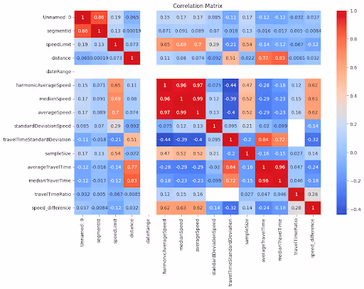
速度制限、道路タイプ、交通量など、さまざまな交通要因がどのように相互に関連しているかを視覚的に表現し、根底にあるパターンと依存関係を明らかにします。

速度制限の分布

オーストラリア全土の制限速度の範囲と共通性を分析し、規制の厳しい地域と制限速度を調整できる可能性のある地域を特定します。

機能道路クラス (FRC) 別の平均速度

道路の機能分類に従って平均速度を分類し、幹線道路と地方道路の交通の流れと渋滞に関する洞察を提供します。

ネピアン・ハイウェイ別の平均速度分布

この主要高速道路沿いの速度パターンに焦点を当て、渋滞しているエリアや効率の高いエリアと、それらが移動時間に与える影響を紹介します。

ストリート名別の平均速度 (上位 10 ストリート)

平均速度で上位 10 の道路を一覧表示し、混雑した都市部や効率的な大通りの交通状況のスナップショットを提供します。

アレクサンドラアベニューストリートロードトラフィック

ピーク時間、平均速度、渋滞ポイントなど、アレクサンドラアベニューの詳細な交通フロー分析を視覚データを使用して示します。

シティリンク有料道路交通

City Link Tollwayの交通パターンの概要をグラフィカルに表示し、効率、速度変動、ピーク混雑時間を強調表示します。

このデータはロケーションマインドが提供していますが、データソースは TomTom です。

Why xMap?

xMap empowers businesses with unparalleled location intelligence and comprehensive data analysis, guiding them towards market leadership and growth.

Close Faster

23

Times more likely to acquire customers
Sign Up for Free

Improve Sales

4.5%

Of the total revenue because of data-driven innovations
Sign Up for Free

Retain More

6

Times more likely to retain customers
Sign Up for Free

Frequently Asked Questions

Find answers to commonly asked questions about our spatial analyst platform.

データセットはどのくらいの頻度で更新されますか?

四半期ごとにデータを更新し、最新の情報にアクセスできるようにしています。

この交通量データはどのように役立ちますか?

トラフィック分析、中央速度、トレンド分析、予測などが該当します。

What types of data are included in the Road Traffic Insights?

This dataset encompasses real-time and historical data on traffic density, accidents, road conditions, and congestion trends.

ムニーブ・レーマン
通常はすぐに返信します
ムニーブ・レーマン
こんにちは
今日はどうすればお手伝いできますか?
Whatsappチャットを開始する