アルゼンチン-道路交通データ

アルゼンチンの道路交通データを詳しく調べて、交通管理を最適化し、交通安全を強化し、持続可能な都市開発を支援してください。

アルゼンチン全土の重要な交通情報

詳細な指標と分析を掘り下げて、アルゼンチン全土の情報に基づいた交通計画と管理に不可欠な交通の流れ、渋滞のホットスポット、速度傾向の微妙な違いを明らかにしてください。

該当なし

Total Number of records
Sign Up for Free

281,290

アルゼンチンの道路の総長(Kms)
Sign Up for Free

ルタ・ナシオナル 9-毎時114km

中央速度別最速道路
Sign Up for Free

Calle 32-17.75km/h

中央速度別の最も遅い道路
Sign Up for Free

アルゼンチンの道路交通のスナップショット

アルゼンチンの道路網の管理に関する新しい視点を提供する包括的なデータセットをプレビューしてください。

Key Variables

詳細な指標と分析を掘り下げて、アルゼンチン全土の情報に基づいた交通計画と管理に不可欠な交通の流れ、渋滞のホットスポット、速度傾向の微妙な違いを明らかにしてください。

Name
Description
Type
TravelTime Standard Deviation
Reflects the variability in travel time, highlighting potential delays and inconsistencies in journey durations.
Float
Time set
A specific time frame under consideration, important for analyzing traffic patterns at different times.
DateTime
Sequence
The order of road segments or data points, important for mapping routes and analyzing traffic flow sequences.
Integer
Sample Size
The number of data points or observations collected, critical for the reliability and accuracy of traffic analysis.
Integer
Standard Deviation speed
A measure of speed variability, indicating the consistency or fluctuation of traffic speeds.
Float
Average speed
The arithmetic mean of speed data, useful for understanding overall traffic flow on a road segment.
Float
Median speed
The middle value of speed measurements, offering a representative speed of traffic under typical conditions.
Float
SpeedLimit
The maximum legally permitted speed on a road segment, crucial for safety and traffic flow analysis.
Integer
Frc
A classification system for roads, determining their hierarchy and role in overall traffic mobility.
Categorical
Street Name
The official name of a road, essential for location identification and route navigation.
String
Distance
The length of a road segment or route, key in calculating travel times and route planning.
Float

Use Cases

How can this dataset benefit you?

強化されたトラフィック管理

アルゼンチンの交通データを活用して、にぎやかな都市の混雑を緩和し、通勤をスムーズにし、移動時間を短縮します。

インフラ計画

道路利用状況と渋滞パターンに関するデータ主導の洞察に基づいて、インフラプロジェクトを戦略的に計画し、優先順位を付けます。

安全対策の実施

綿密な交通分析によって特定された重要なエリアに的を絞った安全対策と介入を実施し、交通事故を大幅に削減します。

中央速度別のロードクラス

streetName medianSpeed
Calle 32 17.75
AU02 18
Calle Mariquita Sánchez de Thompson 22.35
Calle Jeronimo Salguero 22.5
Avenida Comodoro Py 24.6
Ruta Provincial 2 97.65
Ruta Panamericana Ramal Pilar 99.1
Calle Noventa 99.1
Calle San Augustin 99.6
Autopista Colectora Panamericana 100.3
Acceso Panamericana Ramal Pilar 101
Calle Los Pensamientos 101
AU09 102
Autopista Ezeiza-Cañuelas 108
Ruta Nacional 9 114

この分析により、道路タイプによって平均速度がどのように異なるかが明らかになり、交通の流れの効率とインフラの改善が見込まれる分野に関する洞察が得られます。

相互関係マトリックス

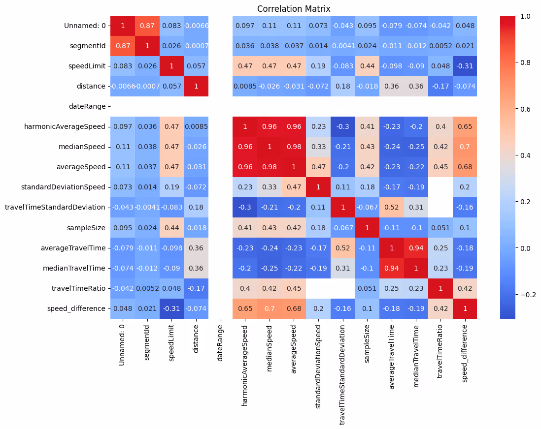
交通量、速度、時間などのさまざまな交通指標間の複雑な関係を明らかにし、道路の利用状況や効率に影響する根本的なパターンを強調するビジュアルツール。

ストリート名別の平均速度 (トップ 10 ストリート)

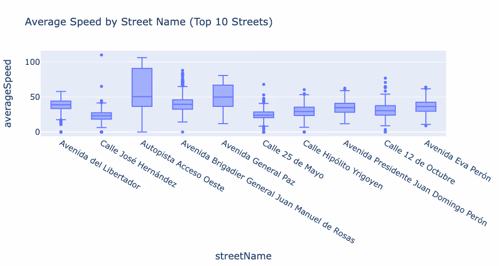
アルゼンチンの平均速度が最も高い道路と最も低い道路を特定し、交通状況と都市交通の課題を明らかにしています。

オートピスタアクセソオエステの平均速度分布

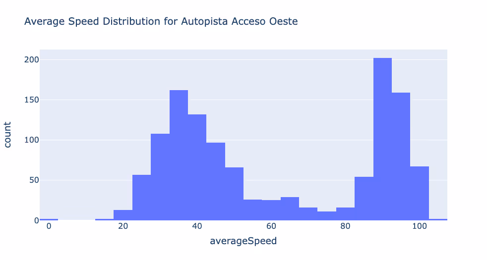
この主要高速道路沿いの速度変化をグラフィカルに表示し、交通の流れと渋滞レベルのスナップショットを提供します。

機能道路クラス (FRC) 別の平均速度

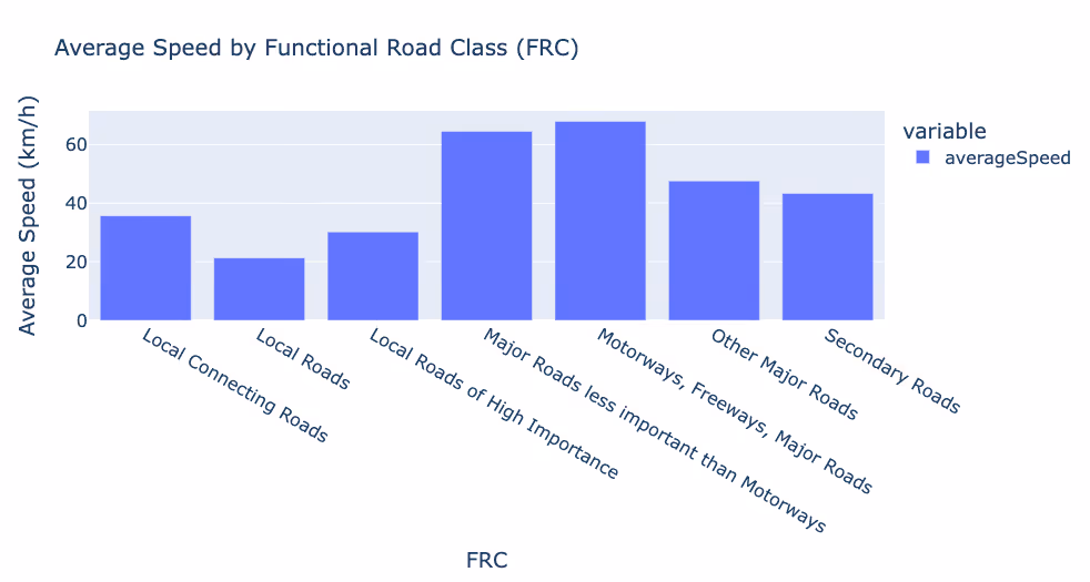
道路の機能分類に従って平均車両速度を分類し、道路の設計と使用が交通動態にどのように影響するかを示します。

速度制限の分布

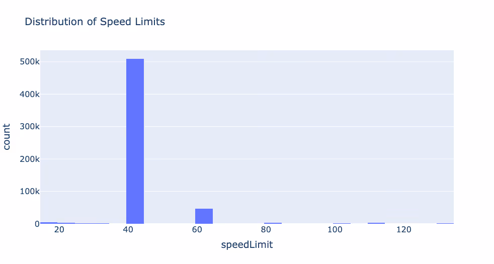
アルゼンチン全土のさまざまな制限速度をマッピングし、規制アプローチとそれが運転行動に与える影響についての展望を示しています。

機能道路クラスの分布

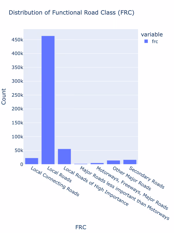
高速道路から地方道路まで、ネットワーク内の道路タイプの多様性と、その全国への分布を強調しています。

ブエノスアイレスの道路交通データ

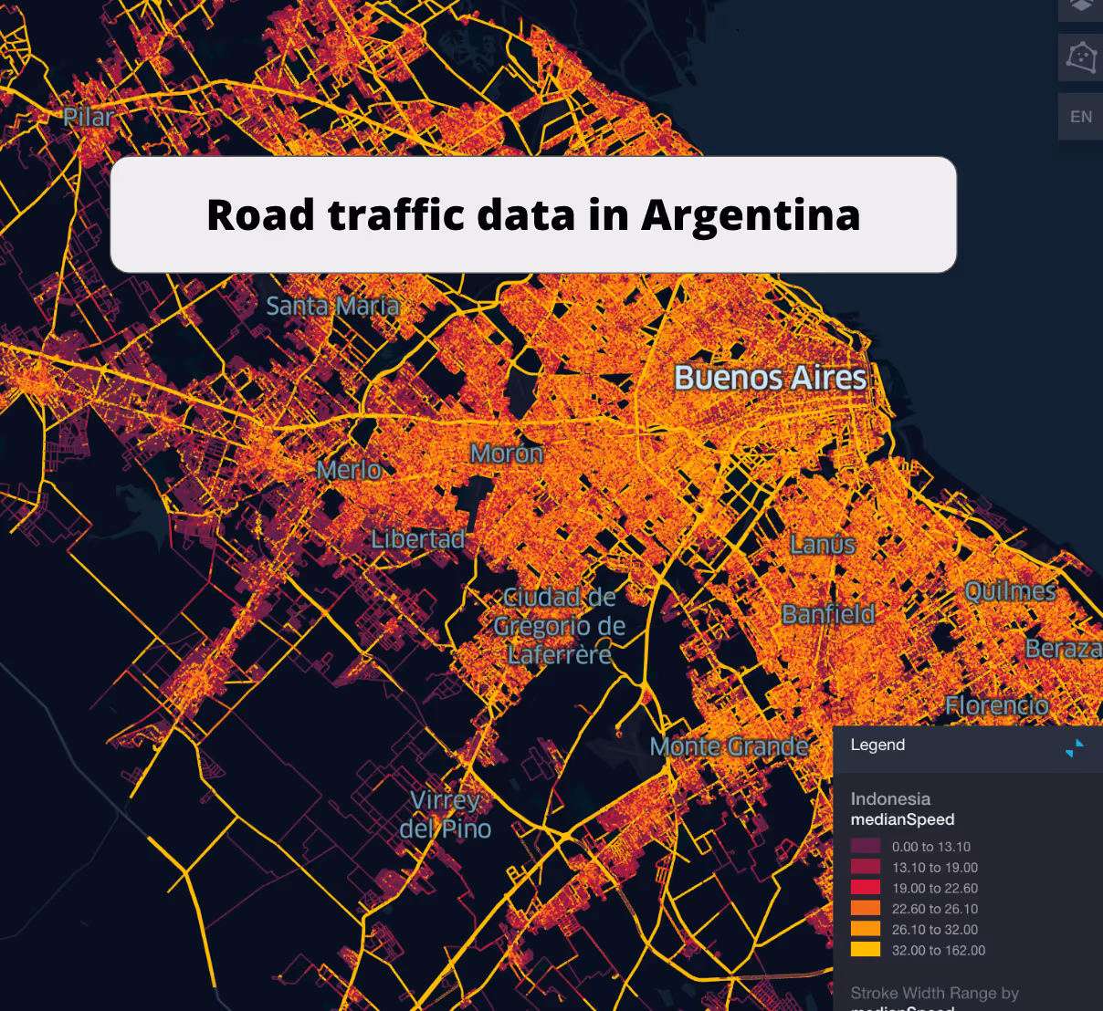
データビジュアライゼーションを使用して渋滞箇所、交通量、ピーク時の移動時間を示し、ブエノスアイレスの交通パターンを包括的に示します。

ブエノスアイレス道路網衛星ビューデータ

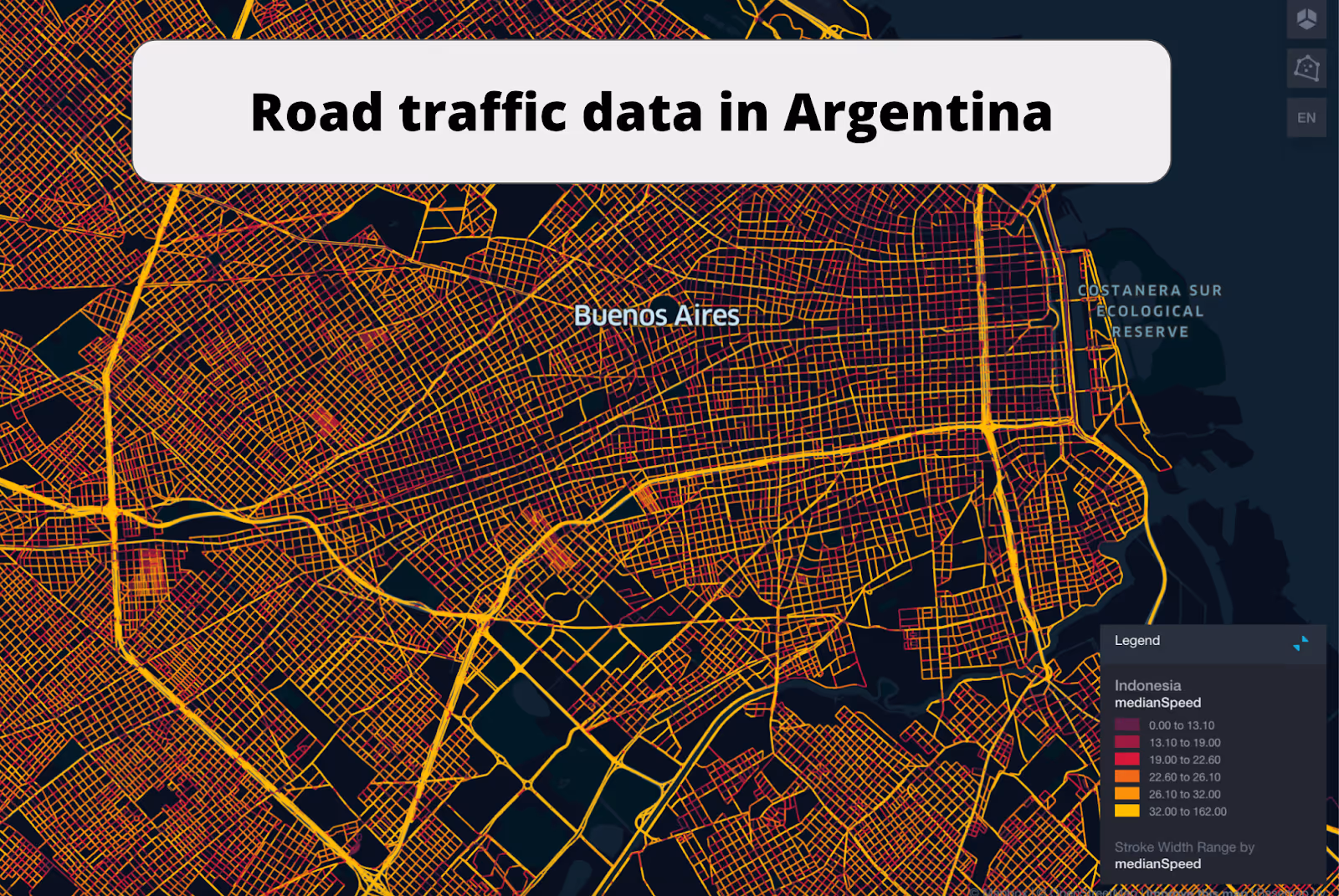
ブエノスアイレスの衛星画像と交通データオーバーレイを組み合わせて、道路網の効率を分析し、改善を計画するための独自のビジュアルツールを提供します。

このデータはロケーションマインドが提供していますが、データソースは TomTom です。

Why xMap?

xMap empowers businesses with unparalleled location intelligence and comprehensive data analysis, guiding them towards market leadership and growth.

Close Faster

23

Times more likely to acquire customers
Sign Up for Free

Improve Sales

4.5%

Of the total revenue because of data-driven innovations
Sign Up for Free

Retain More

6

Times more likely to retain customers
Sign Up for Free

Frequently Asked Questions

Find answers to commonly asked questions about our spatial analyst platform.

この交通量データはどのように役立ちますか?

トラフィック分析、中央速度、トレンド分析、予測などが該当します。

What types of data are included in the Road Traffic Insights?

This dataset encompasses real-time and historical data on traffic density, accidents, road conditions, and congestion trends.

How can this road traffic dataset benefit my business or project?

Leverage this dataset for site selection, analyze road traffic on your desired business location, enhanced route planning, strategic urban development projects, and to implement proactive traffic management strategies.

ムニーブ・レーマン
通常はすぐに返信します
ムニーブ・レーマン
こんにちは
今日はどうすればお手伝いできますか?
Whatsappチャットを開始する