Navigating Italy's Road Traffic Data in 2024: All You need to know
- Remove the current class from the content27_link item as Webflows native current state will automatically be applied.
- To add interactions which automatically expand and collapse sections in the table of contents, select the content27_h-trigger element, add an element trigger, and select Mouse click (tap).
- For the 1st click, select the custom animation Content 27 table of contents [Expand], and for the 2nd click, select the custom animation Content 27 table of contents [Collapse].
- In the Trigger Settings, deselect all checkboxes other than Desktop and above. This disables the interaction on tablet and below to prevent bugs when scrolling.
Having the most recent road traffic information is vital for policymakers, urban planners, and commuters in Italy's intricate transportation system to navigate successfully. As we move forward in 2024, it is becoming more and more important to grasp the road traffic data of Italy. An in-depth examination of Italy's road traffic data, including urban areas and rural roads, offers valuable information on congestion, infrastructure requirements, and changing mobility trends impacting the country. Join us as we examine the road traffic data of Italy in 2024, investigating the complexities and impacts on the country's transportation network.
Decoding Italy's Road Traffic Data
Average Speed
The average speed along Italy's road segments provides a snapshot of traffic flow, aiding in the identification of congestion hotspots and the assessment of overall mobility. By analyzing the Average Speed Distribution graph for key routes such as the Tangenziale Ovest Road, fluctuations in speed become apparent. Fluctuations in speed data indicate changes in traffic congestion, allowing officials to introduce specific interventions like traffic management strategies or infrastructure improvements to reduce congestion points.

Speed Limit
Speed limits play a crucial role in maintaining road safety across Italy’s diverse road network while also improving traffic flow efficiency. The Speed Limit Distribution graph highlights the variation in speed restrictions across different types of roads, from dense urban streets to high-speed Italian highways. When speed limits are aligned with specific road features and actual traffic behavior, transport authorities and policymakers can enhance safety measures and better coordinate overall traffic movement.

Functional Road Classes
Italy employs the Functional Road Class (FRC) system to categorize its road network by hierarchy and function. This system provides a categorical representation of road types, spanning major highways to local access routes. Recognizing road classifications is vital for informed infrastructure planning, guiding decisions on maintenance, capacity improvements, and route optimization to meet diverse traffic demands.

Distance
Distance metric is fundamental in delineating the spatial layout of Italy's road network. With a total length of 487,700 kilometers, Italy's roads weave through diverse landscapes, connecting urban centers, rural communities, and economic hubs. Analyzing distance data facilitates route planning, infrastructure investment decisions, and the identification of connectivity gaps. By enhancing spatial connectivity, Italy can foster economic development, improve accessibility, and enhance the overall efficiency of its transportation network.
Navigating Italy's Road Traffic Data with Graphs and Maps
In the intricate tapestry of Italy's transportation infrastructure, understanding and managing road traffic data is essential for optimizing mobility and ensuring efficient travel across the country. Visual aids, including graphs and maps, emerge as indispensable tools, providing stakeholders with comprehensive insights to navigate through the complexities of Italy's road networks, address congestion, and enhance overall transportation efficiency.
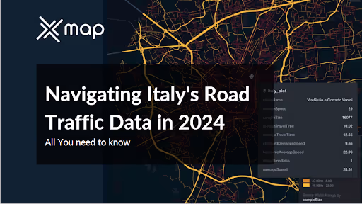
Tangenziale Ovest Road Network Data

Tangenziale Ovest, a crucial part of Italy's transport network, utilizes maps for strategic decision-making. These maps provide insights into traffic flow, infrastructure, and congestion points, enabling efficient resource deployment and real-time interventions to minimize disruptions. They also aid in communicating data to the public, fostering community engagement and aligning with local needs, thereby enhancing the efficiency and safety of Italy's transportation infrastructure.
Median Speeds by Street Names
Italy's streets exhibit diverse median speeds in 2024, reflecting varying traffic dynamics. From urban corridors like Via Circonvallazione Idroscalo, averaging 46.1 km/h, to major thoroughfares like Autostrada dei Laghi at 102 km/h, each street tells a unique story of traffic flow. Understanding these median speeds offers insights into traffic patterns, informing transportation management and urban planning strategies nationwide.
Average Speed by Functional Road Class (FRC)
In Italy, the average speed by Functional Road Class (FRC) clearly illustrates the variation in travel patterns across different road types. High-speed motorways, used mainly for long-distance travel, average over 80 km/h, offering fast and efficient connectivity. In contrast, local connector roads typically operate at much lower speeds around 30 to 40 km/h where community access and traffic safety are prioritized over speed. These FRC-based speed insights play a vital role in shaping transportation policies and guiding infrastructure planning, ensuring balanced mobility and road safety across Italy’s complex road system.

Average Speed by Street Name (Top 10 Streets)
In Italy, the top 10 streets showcase a distinct contrast in average speeds. Tangenziale Est, Tangenziale Ovest, and Tangenziale Nord lead with notably higher averages around 90 km/h, serving as vital intercity routes. Meanwhile, the remaining streets maintain speeds of approximately 40 km/h, reflecting localized traffic and urban congestion. Recognizing these differences aids in strategic transportation planning and resource allocation for Italy's diverse road network.

Use cases of Italy's Road Traffic Data
Optimizing Urban Mobility
Urban planners rely on detailed traffic data analysis to tackle urban challenges like congestion and inefficient traffic flow. By studying traffic trends, including peak travel times and high-density routes, city officials can strategically allocate resources to ease pressure on road networks and enhance urban mobility. Key approaches—such as coordinated traffic signals, dynamic routing algorithms, and enhancements to public transportation systems—are applied to shorten commute times and elevate the overall travel experience for both residents and visitors in urban areas.
Strategic Infrastructure Development
Using information to make decisions is crucial for progressing transportation infrastructure, as data plays a vital role in setting project priorities. By analyzing traffic volume, congestion levels, and usage patterns closely, stakeholders can identify areas in need of enhancements or expansions. This technique, based on data, ensures that resources are distributed efficiently to improve road networks for economic expansion, urban progress, and evolving mobility needs.
Enhancing Road Safety Measures
Dealing with road safety issues involves a diverse strategy based on thorough analysis of traffic data. Authorities can identify dangerous locations and possible risks on roads by analyzing past accident records and current traffic updates. The importance of decreasing risks and lowering accident rates lies in the execution of specific safety measures like upgraded signs, better visibility, and efficient speed control systems. Moreover, educational initiatives that promote safe driving behavior are essential for creating a road safety culture and ensuring the safety of all travelers.
Conclusion
Ultimately, it is crucial to use Italy's road traffic data in 2024 to effectively navigate the country's transportation system. From improving city transportation to strategic infrastructure growth and increasing road safety measures, the uses of this data have a wide-ranging and significant effect. By utilizing information on typical speeds, types of roads, and traffic behaviors, stakeholders can make educated choices to tackle traffic jams, enhance productivity, and guarantee the well-being of all road users across the country. As Italy moves forward, a comprehensive grasp of its road traffic information will remain essential in influencing transportation policies and infrastructure investments to cater to the changing requirements of its population and visitors—just as regional infrastructure insights, like the distribution of Texas Roadhouse restaurants in the U.S., reflect how location-based data supports planning in other countries.
xMap Role in Utilizing Italy's Road Traffic Data
- Advanced Visualization: xMap transforms complex Italy road traffic data into intuitive maps and charts, enabling businesses to easily grasp traffic patterns and congestion areas. This visual representation facilitates quick decision-making and strategic planning.
- Comprehensive Data Analysis: Businesses gain access to detailed information on traffic flow, speed limits, and median speeds, allowing for a thorough understanding of Italy's road traffic dynamics. By analyzing these factors, businesses can optimize routes, logistics, and customer service strategies effectively.
- Updated and Reliable Data: With continuous updates, xMap ensures that businesses have access to the most recent and reliable Italy road traffic data. This timely information enables businesses to make informed decisions and adapt to changing traffic conditions promptly.
- Predictive Analytics: xMap offers advanced data analysis tools that allow businesses to predict traffic patterns and plan accordingly. By leveraging predictive analytics, businesses can anticipate congestion areas and proactively adjust routes or schedules to minimize delays and optimize operations.
- User-Friendly Interface: xMap's intuitive interface makes it easy for all stakeholders to interact with the data and extract actionable insights. Whether analyzing specific regions, timeframes, or traffic parameters, businesses can customize their analysis to align with their objectives and make informed decisions confidently.
To get all the details about Italy Traffic data, See this dataset page.
Or visit our catalog page.
If you’d like to data samples for other countries like Egypt, USA, Switzerland, Japan, Turkey, UAE, and others, please visit our platform and sign up.
This data is provided by LocationMind but the data source is TomTom

Subscribe for advanced Data analysis Tips and Reports

Get in Touch
Whatever your goal or project size, we will handle it.
We will ensure you 100% satisfication.
"We focus on delivering quality data tailored to businesses needs from all around the world. Whether you are a restaurant, a hotel, or even a gym, you can empower your operations' decisions with geo-data.”

