How Many CVS Stores Are in the USA in 2025? | Xmap AI

- Remove the current class from the content27_link item as Webflows native current state will automatically be applied.
- To add interactions which automatically expand and collapse sections in the table of contents, select the content27_h-trigger element, add an element trigger, and select Mouse click (tap).
- For the 1st click, select the custom animation Content 27 table of contents [Expand], and for the 2nd click, select the custom animation Content 27 table of contents [Collapse].
- In the Trigger Settings, deselect all checkboxes other than Desktop and above. This disables the interaction on tablet and below to prevent bugs when scrolling.
Navigating the retail landscape to choose the right location strategy can be daunting, but understanding key players like CVS stores in the USA can offer a treasure trove of insights. As one of the largest pharmacy chains, CVS is not only central to healthcare but also to community convenience. In this article, we'll explore how CVS's distribution, services, customer ratings, and real-world data serve as a cornerstone in strategic planning.
“The best way to predict the future is to understand the present.”
With this exploration, you'll uncover how data-driven insights empower your business decisions, turning the mundane into your strategic advantage. From bustling urban hubs to small town essentials, join us as we uncover the layers of what makes CVS a distinguishing player in American retail and how you can leverage this information for your own location success.
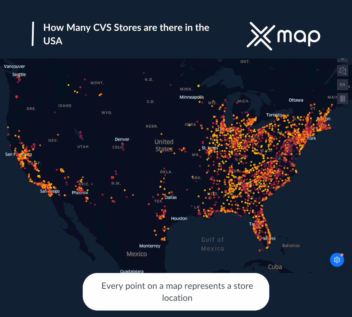
How Many CVS Stores are in the USA in 2024?
With an impressive 5,856 CVS stores scattered across the United States, the convenience and reach of this pharmaceutical giant are hard to overlook. This vast number highlights CVS’s strategic planning, ensuring that communities nationwide have access to essential health and wellness products.
The extensive distribution of these outlets is not just about numbers; it represents a thoughtfully executed plan to cater to diverse needs efficiently. By understanding the distribution and operations of CVS stores, one can gain valuable insights into effective location strategies.
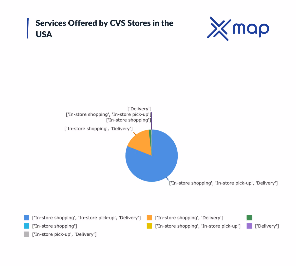
Services Offered by CVS Stores in the USA
- CVS stores predominantly offer a combination of in-store shopping, in-store pick-up, and delivery services, with 4742 locations providing this comprehensive service set.
- A significant number of locations, 1008 to be precise, focus on in-store shopping and delivery options, indicating a strong emphasis on flexibility in how customers receive products.
- Interestingly, there are 88 locations where the specific services provided have not been disclosed, which may indicate a need for additional data gathering or varied service offerings.
- Only a handful of stores, 9 in total, are dedicated solely to in-store shopping, suggesting minimal exclusive reliance on this mode.
- The count drops significantly with rare configurations, such as just in-store pick-up and delivery being available at only 1 location, and sole delivery featured in only 3 locations.
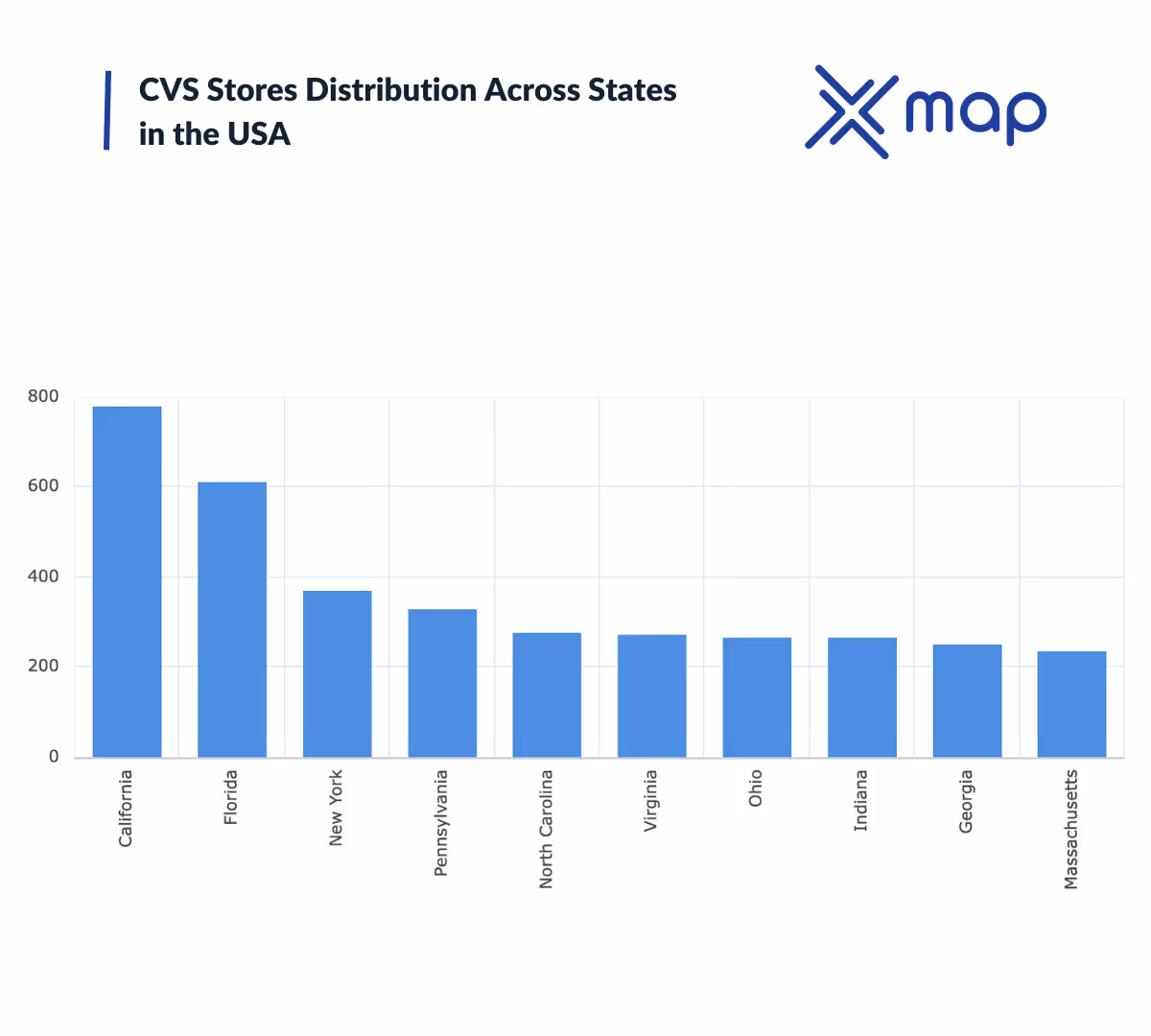
CVS Stores Distribution Across States
- California leads with 778 locations, making it the primary hub for CVS stores, reflecting its large population and urban centers.
- Florida follows with 611 stores, likely influenced by its status as a major tourist destination and the large retiree population.
- New York, Pennsylvania, and North Carolina round out the top five, showing strong CVS presence in densely populated and urbanized states.
- States like Ohio and Indiana both have 265 locations, demonstrating CVS's strategic placement in the midwestern market.
- Massachusetts, with 235 locations, stands out considering its relatively smaller geographical size, indicating a high store density.
- Each state in the top 10 has over 230 locations, reflecting CVS's substantial nationwide distribution strategy to meet diverse local demands.
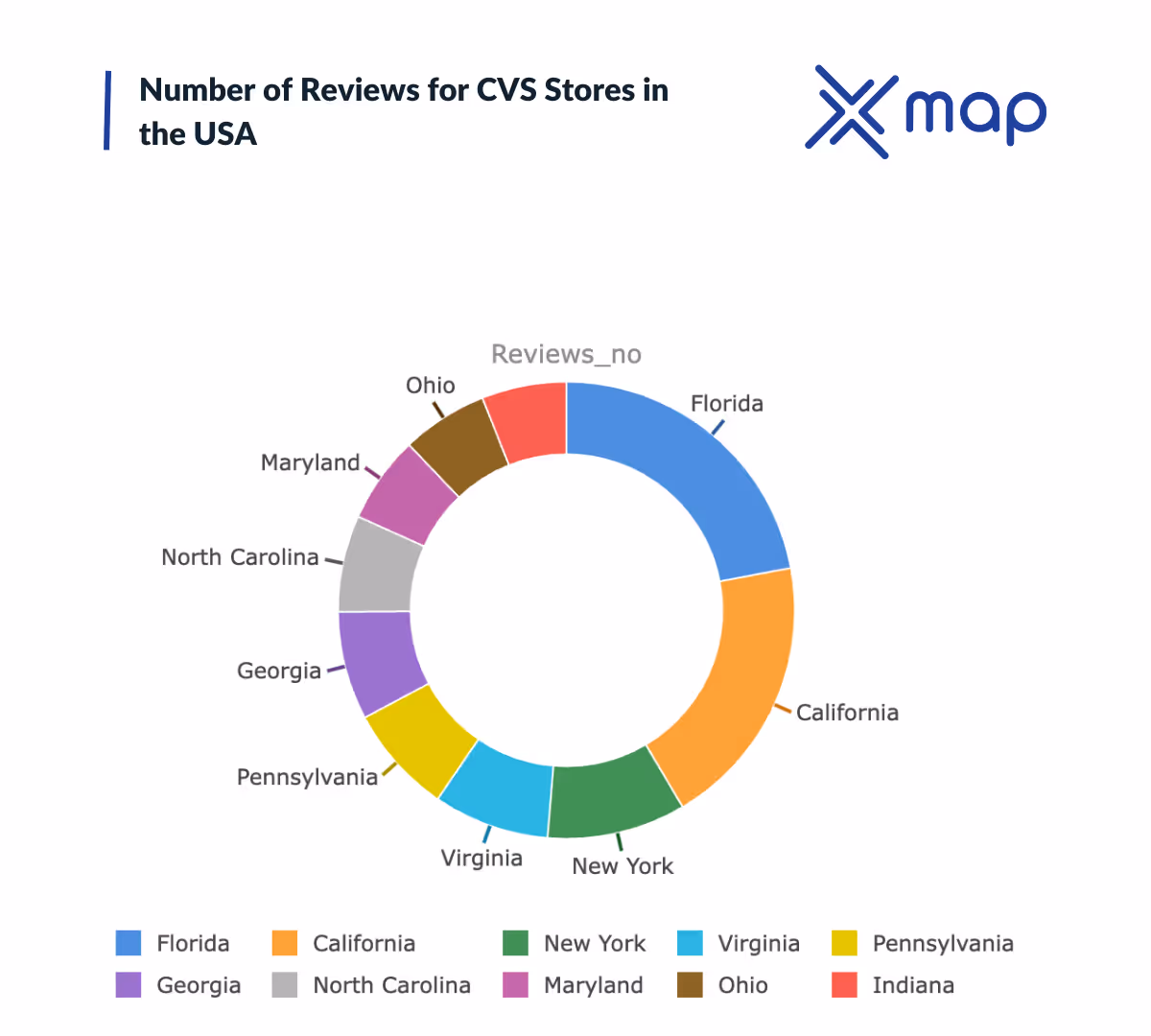
Number of Reviews for CVS Stores in the USA
- Florida leads with the highest number of reviews, indicating a significant customer engagement or high traffic in CVS stores located there.
- California follows, showing strong customer activity which could suggest a dense network of CVS outlets or a larger customer base.
- Notably, New York, Virginia, and Pennsylvania make the top five, highlighting these states as major points for customer interaction with CVS.
- This distribution suggests a strategic placement of CVS stores in states with a high population or demand for pharmacy services.
- The data might indicate potential growth opportunities for CVS in these regions based on customer engagement reflected in reviews.
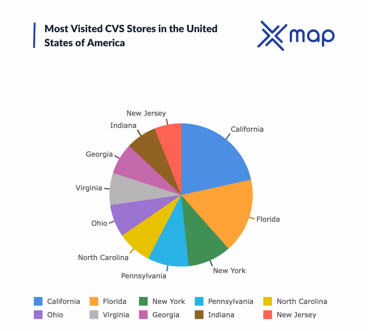
Most Visited CVS Stores in the USA
Looking at the traffic scores, it's evident that California commands a significant lead, highlighting a strong CVS presence and consistent customer visits. States like Florida and New York also show high levels of customer engagement, reinforcing their importance in CVS’s operational strategy. Additionally, Pennsylvania, North Carolina, and Ohio further validate the strategic value of eastern and southeastern regions, reflecting their contribution to overall store traffic and likely sales performance.
Top Rated CVS Stores in the USA
- California leads the way with a remarkable sum of ratings, showcasing its vibrant CVS presence and possibly indicating a higher customer footfall and engagement.
- Florida and New York follow, with these states possibly benefiting from both high population density and tourism, driving customer expectations and experiences.
- Pennsylvania and Indiana reflect strong customer engagement, ranking fourth and fifth respectively, which might point to well-established stores and community trust.
- States like North Carolina, Ohio, and Virginia show competitive engagement levels, likely indicating strategic store distribution catering effectively to local demands.
- Notably, Georgia and New Jersey round out the top ten, suggesting that these areas also experience a healthy interaction with CVS stores, though less than the leading states.
How xMap's Polygon AI tool Can Help
When it comes to strategizing your business location, understanding the geographical data can make all the difference. Enter xMap's Polygon AI tool—a revolutionary system designed to transform how you view and utilize geographical information. This intelligent tool provides detailed mapping capabilities that allow you to visualize data on a granular level, optimizing your decision-making process.

Imagine being able to identify high-traffic areas, visualize population density, or even correlate data about nearby businesses. xMap's Polygon AI makes it possible with its intricate yet user-friendly interface. By leveraging its comprehensive dataset, you can effectively pinpoint potential spots for your CVS store, ensuring you position it where customer demand is highest and competitors are minimal.

Moreover, this tool allows you to simulate various scenarios. Whether it's assessing how a new highway might impact foot traffic or analyzing demographic changes, xMap empowers you with actionable insights. As you align with CVS's goal to meet healthcare needs and enhance shopping experiences, xMap can guide you towards making strategic decisions that benefit both the company and its customers.

In an era where data drives decisions, having access to such a powerful tool puts you ahead. So, whether you're planning on expanding an existing network of stores or setting up a new location, xMap's Polygon AI tool is your go-to solution for intelligent, data-driven planning.
Conclusion
Overall, CVS stores are a crucial part of the healthcare and retail landscape in the USA, offering a wide range of services and products across numerous locations. Through analyzing their distribution, customer feedback, and store visitation data, businesses can gain valuable insights to optimize their location strategies and improve customer satisfaction. For a broader understanding of retail expansion trends, this comprehensive guide on how many Dollar General stores are in the United States offers additional context on large-scale retail distribution.
- Generative AI powered xMap Polygon AI can assist businesses in predicting optimal store locations by analyzing geographic and demographic data.
- It enhances customer targeting by identifying areas with high potential for foot traffic.
- The tool allows businesses to compare different locations using AI-driven insights, thereby improving decision-making processes.
- By leveraging this technology, companies can reduce the time and costs associated with traditional market research.
Subscribe for advanced Data analysis Tips and Reports

Get in Touch
Whatever your goal or project size, we will handle it.
We will ensure you 100% satisfication.
"We focus on delivering quality data tailored to businesses needs from all around the world. Whether you are a restaurant, a hotel, or even a gym, you can empower your operations' decisions with geo-data.”

