Vietnam | Road Traffic Data
Explore the bustling dynamics of Vietnam’s road traffic with our comprehensive dataset, providing detailed insights into traffic flows, congestion patterns, and vehicle types across both rapidly growing urban centers like Hanoi and Ho Chi Minh City and smaller rural roads. Ideal for transportation planners, government agencies, and urban developers, this dataset is crucial for crafting effective traffic management strategies, optimizing public transportation systems, and guiding sustainable infrastructure projects throughout Vietnam.
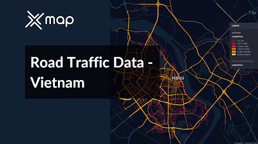


Vital Traffic Insights across the Vietnam
Analyze extensive information and studies to uncover crucial insights about traffic congestion, busy areas, and necessary speed changes, aiding in efficient transportation planning throughout Vietnam.
Download a Sample
Preview the depth and breadth of our traffic data collection, showcasing how granular insights can revolutionize transportation planning and management in Vietnam.
.avif)
Key Variables
Analyze extensive information and studies to uncover crucial insights about traffic congestion, busy areas, and necessary speed changes, aiding in efficient transportation planning throughout Vietnam.
Use Cases
How can this dataset benefit you?
Utilize Vietnam's road traffic data to manage and reduce congestion in major cities like Hanoi and Ho Chi Minh City. Implement dynamic traffic management systems that adjust traffic light timings and traffic flows based on real-time data, and introduce congestion pricing to discourage the use of private vehicles during peak hours. This approach aims to streamline urban mobility and reduce environmental impact.
Leverage traffic flow data to enhance the efficiency and coverage of public transportation systems across Vietnam. Use insights from traffic patterns to identify areas poorly served by public transit and adjust bus and metro services accordingly. Enhance the integration of different modes of transport to create a more seamless and attractive public transportation network, encouraging a shift away from private car usage.
Employ traffic and accident data to identify high-risk sections on national highways, particularly those experiencing high volumes of traffic and accidents. Implement targeted safety measures such as improved road signage, enhanced road surface conditions, and strict enforcement of traffic laws. Additionally, use this data to plan educational campaigns targeting drivers about safe driving practices, ultimately reducing the frequency and severity of traffic accidents.
Everything You need to know to know about the Road Traffic of Vietnam
Median Vehicle Speeds by Road Names
This analysis evaluates median vehicle speeds across different road types, highlighting efficiency and congestion levels from highways to local streets.
Speed Limit Distribution
Explores the range and prevalence of speed limits throughout Vietnam, identifying areas with strict regulations and potential zones for speed limit adjustments.

Functional Road Class (FRC) Distribution
Illustrates the variety of road types within the network, from major thoroughfares to local streets, and their distribution across the territory.

Average Speed by Functional Road Class (FRC)
Analyzes average speeds based on road functional classifications, providing insights into traffic flow and congestion differences between arterial roads and local streets.

Average Speed Distribution for Phố Minh Khai
Examines speed patterns along this major road, highlighting areas of congestion or high efficiency and their impact on travel times.

Top 10 Streets by Average Speed
Lists the top 10 streets by average speed, offering an overview of traffic conditions in busy urban areas or on efficient routes.

Hanoi Street Traffic Analysis
Presents a detailed examination of traffic flow on Hanoi’s streets, including peak traffic times, average speeds, and congested areas, supported by visual data.

Why xMap?
xMap empowers businesses with unparalleled location intelligence and comprehensive data analysis, guiding them towards market leadership and growth.
Frequently Asked Questions
Find answers to commonly asked questions about our spatial analyst platform.
This dataset encompasses real-time and historical data on traffic density, accidents, road conditions, and congestion trends.
Leverage this dataset for site selection, analyze road traffic on your desired business location, enhanced route planning, strategic urban development projects, and to implement proactive traffic management strategies.
At xMap, we are committed to ensuring that our clients can leverage our datasets effectively. We provide comprehensive technical support, including help with data integration, troubleshooting, and optimization of data use. Additionally, we offer consulting services to help businesses understand and analyze traffic data to meet their specific strategic objectives.

