Turkey - Road Traffic Data
Dive into the complexities of Turkey’s diverse road networks with our extensive traffic dataset, providing detailed insights into traffic volumes, congestion trends, and vehicle types across urban centers and connecting rural routes. Essential for government agencies, urban planners, and transportation companies, this dataset is pivotal for crafting robust traffic management strategies, optimizing public transit operations, and supporting infrastructural improvements throughout Turkey.


Vital Traffic Insights across the Turkey
Analyze extensive information and studies to uncover key insights on traffic flow intricacies, congested areas, and necessary speed changes, aiding in efficient transportation planning throughout Turkey.
Download a Sample
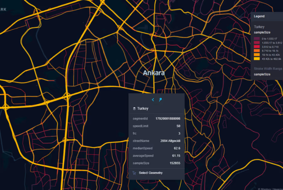
Preview the depth and breadth of our traffic data collection, showcasing how granular insights can revolutionize transportation planning and management in Turkey.
.avif)
Key Variables
Analyze extensive information and studies to uncover key insights on traffic flow intricacies, congested areas, and necessary speed changes, aiding in efficient transportation planning throughout Turkey.
Use Cases
How can this dataset benefit you?
Utilize Turkey's road traffic data to manage and optimize commuter flows in Istanbul, particularly across the two continents connected by the Bosphorus Bridge. Implement predictive analytics to forecast congestion patterns and dynamically manage toll rates and lane assignments. Integrate this information with public transit scheduling, encouraging a shift from private vehicle use to public transport during peak hours.
Leverage traffic data to enhance traffic management in popular coastal tourist destinations such as Antalya and Bodrum. Use insights from traffic patterns during the tourist season to implement temporary traffic measures, such as additional parking facilities and rerouted traffic flows, to accommodate the influx of visitors efficiently and maintain smooth traffic conditions.
Employ road traffic data to identify rural areas with high rates of accidents and implement targeted safety improvements. This could include upgrading road infrastructure, improving signage, adding better lighting, and conducting safety campaigns focused on local drivers and pedestrians. These initiatives aim to reduce accident rates and enhance road safety across Turkey’s diverse landscapes.
Everything You need to know to know about the Road Traffic of Turkey
Median Vehicle Speeds by Road Names
This analysis evaluates median vehicle speeds across different road types, highlighting efficiency and congestion levels from highways to local streets.
Speed Limit Distribution
Explores the range and prevalence of speed limits throughout Turkey, identifying areas with strict regulations and potential zones for speed limit adjustments.

Functional Road Class (FRC) Distribution
Illustrates the variety of road types within the network, from major thoroughfares to local streets, and their distribution across the territory.

Average Speed by Functional Road Class (FRC)
Analyzes average speeds based on road functional classifications, providing insights into traffic flow and congestion differences between arterial roads and local streets.

Average Speed Distribution for Dumlupınar Bulvarı
Examines speed patterns along this major road, highlighting areas of congestion or high efficiency and their impact on travel times.

Top 10 Streets by Average Speed
Lists the top 10 streets by average speed, offering an overview of traffic conditions in busy urban areas or on efficient routes.

Ankara Street Traffic Analysis
Presents a detailed examination of traffic flow on Ankara’s streets, including peak traffic times, average speeds, and congested areas, supported by visual data.

Why xMap?
xMap empowers businesses with unparalleled location intelligence and comprehensive data analysis, guiding them towards market leadership and growth.
Frequently Asked Questions
Find answers to commonly asked questions about our spatial analyst platform.
This dataset encompasses real-time and historical data on traffic density, accidents, road conditions, and congestion trends.
Leverage this dataset for site selection, analyze road traffic on your desired business location, enhanced route planning, strategic urban development projects, and to implement proactive traffic management strategies.
At xMap, we are committed to ensuring that our clients can leverage our datasets effectively. We provide comprehensive technical support, including help with data integration, troubleshooting, and optimization of data use. Additionally, we offer consulting services to help businesses understand and analyze traffic data to meet their specific strategic objectives.

