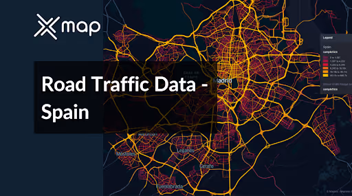
Spain - Road Traffic Data
Navigate the vibrant and diverse roadways of Spain with our comprehensive traffic dataset, which provides detailed insights into traffic flows, congestion levels, and vehicle types across urban centers and scenic routes. Ideal for local government officials, urban planners, and transportation companies, this dataset is essential for crafting effective traffic management strategies, enhancing public transportation systems, and supporting sustainable infrastructure projects throughout Spain.


Vital Traffic Insights across the Spain
Examine comprehensive data and research to reveal important understandings about traffic flow complexities, congested zones, and needed speed adjustments, assisting in effective transportation planning across Spain.
Download a Sample
Preview the depth and breadth of our traffic data collection, showcasing how granular insights can revolutionize transportation planning and management in Spain.
Key Variables
Examine comprehensive data and research to reveal important understandings about traffic flow complexities, congested zones, and needed speed adjustments, assisting in effective transportation planning across Spain.
Use Cases
How can this dataset benefit you?
Utilize Spain's road traffic data to implement dynamic traffic management systems in major cities such as Madrid, Barcelona, and Valencia. These systems can use real-time data to optimize traffic light timings, manage congestion proactively, and provide drivers with alternative route suggestions during peak traffic times, thereby reducing congestion and enhancing urban mobility.
Leverage traffic data to manage and optimize traffic flows during peak tourist seasons in popular coastal regions like Costa del Sol and the Balearic Islands. Use insights from traffic patterns to implement seasonal traffic measures, such as temporary one-way streets, increased public transport options, and strategic parking management to accommodate the influx of tourists efficiently.
Employ traffic volume and pattern analysis to inform infrastructure planning and development across Spain. Focus on identifying and addressing critical bottlenecks in the road network, planning new road constructions or expansions where necessary, and enhancing existing infrastructures such as bridges and tunnels to improve connectivity and reduce travel times.
Everything You need to know to know about the Road Traffic of Spain
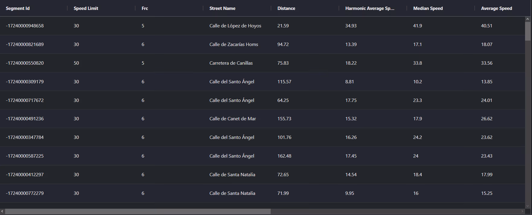
Median Vehicle Speeds by Road Names
This analysis evaluates median vehicle speeds across various road types, highlighting efficiency and congestion levels from highways to local streets.
Speed Limit Distribution
Explores the range and prevalence of speed limits throughout Spain, identifying areas with strict regulations and potential zones for speed limit adjustments.

Functional Road Class (FRC) Distribution
Illustrates the variety of road types within the network, from major thoroughfares to local streets, and their distribution across the territory.

Average Speed by Functional Road Class (FRC)
Analyzes average speeds based on road functional classifications, providing insights into traffic flow and congestion differences between arterial roads and local streets.
Average Speed Distribution for Avenida de América
Examines speed patterns along this major road, highlighting areas of congestion or high efficiency and their impact on travel times.

Top 10 Streets by Average Speed
Lists the top 10 streets by average speed, offering an overview of traffic conditions in busy urban areas or on efficient routes.

Madrid Street Traffic Analysis
Presents a detailed examination of traffic flow on Madrid’s streets, including peak traffic times, average speeds, and congested areas, supported by visual data.

Why xMap?
xMap empowers businesses with unparalleled location intelligence and comprehensive data analysis, guiding them towards market leadership and growth.
Frequently Asked Questions
Find answers to commonly asked questions about our spatial analyst platform.
This dataset encompasses real-time and historical data on traffic density, accidents, road conditions, and congestion trends.
Leverage this dataset for site selection, analyze road traffic on your desired business location, enhanced route planning, strategic urban development projects, and to implement proactive traffic management strategies.
At xMap, we are committed to ensuring that our clients can leverage our datasets effectively. We provide comprehensive technical support, including help with data integration, troubleshooting, and optimization of data use. Additionally, we offer consulting services to help businesses understand and analyze traffic data to meet their specific strategic objectives.

