Slovakia - Road Traffic Data
Explore Slovakia’s road networks with our comprehensive traffic dataset, which provides in-depth insights into traffic volumes, congestion patterns, and vehicle types across the country. Ideal for government planners, urban developers, and transport analysts, this dataset supports effective traffic management, facilitates optimized route planning, and aids in the strategic development of transportation infrastructure throughout Slovakia.
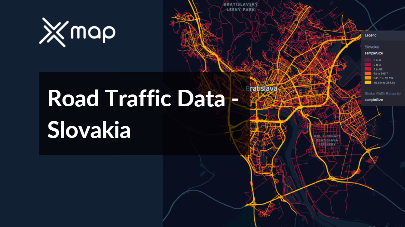


Vital Traffic Insights across the Slovakia
Delve into detailed data and research to gain a deep understanding of traffic flow intricacies, congested areas, and necessary speed adjustments for effective transportation planning in Slovenia.
Download a Sample
Preview the depth and breadth of our traffic data collection, showcasing how granular insights can revolutionize transportation planning and management in Slovakia.
.avif)
Key Variables
Delve into detailed data and research to gain a deep understanding of traffic flow intricacies, congested areas, and necessary speed adjustments for effective transportation planning in Slovenia.
Use Cases
How can this dataset benefit you?
Utilize Slovakia's road traffic data to enhance commuter routes in Bratislava, addressing congestion and optimizing flow during peak hours. Implement traffic management solutions such as adjusted traffic light sequences and real-time public transport updates to commuters through mobile apps, improving efficiency and reducing travel times for daily commuters.
Leverage traffic and vehicle type data to strategically plan and deploy electric vehicle charging stations across Slovakia. Use insights from the data to identify high traffic areas with a growing number of electric vehicles to ensure the charging infrastructure meets current demand and encourages further adoption of EVs.
Employ traffic data to identify roads and intersections with high accident rates throughout Slovakia. Analyze traffic patterns to determine contributing factors and implement safety improvements such as better signage, road widening, the introduction of roundabouts, and targeted law enforcement presence to reduce accident rates and enhance safety for all road users.
Everything You need to know to know about the Road Traffic of Slovakia
Median Vehicle Speeds by Road Names
This analysis evaluates median vehicle speeds across various road types, highlighting efficiency and congestion levels from highways to local streets.
Speed Limit Distribution
Explores the range and prevalence of speed limits throughout Slovakia, identifying areas with strict regulations and potential zones for speed limit adjustments.

Functional Road Class (FRC) Distribution
Illustrates the variety of road types within the network, from major thoroughfares to local streets, and their distribution across the territory.

Average Speed by Functional Road Class (FRC)
Analyzes average speeds based on road functional classifications, providing insights into traffic flow and congestion differences between arterial roads and local streets.

Average Speed Distribution for Dolnozemská cesta
Examines speed patterns along this major road, highlighting areas of congestion or high efficiency and their impact on travel times.

Top 10 Streets by Average Speed
Lists the top 10 streets by average speed, offering an overview of traffic conditions in busy urban areas or on efficient routes.

Bratislava Street Traffic Analysis
Presents a detailed examination of traffic flow on Bratislava’s streets, including peak traffic times, average speeds, and congested areas, supported by visual data.

Why xMap?
xMap empowers businesses with unparalleled location intelligence and comprehensive data analysis, guiding them towards market leadership and growth.
Frequently Asked Questions
Find answers to commonly asked questions about our spatial analyst platform.
This dataset encompasses real-time and historical data on traffic density, accidents, road conditions, and congestion trends.
The Andorra Road Traffic dataset includes a variety of information such as historical traffic data, congestion levels, traffic flow patterns, and types of vehicles on the roads. This data helps in understanding traffic dynamics and planning accordingly.

