Saudi Arabia - Road Traffic Data
This dataset offers an in-depth view of road traffic patterns in Saudi Arabia, encompassing data on traffic densities, average speeds, and congestion during peak hours, both in real-time and historically.


Comprehensive Traffic Data Insights
Dive into Detailed Statistics and Metrics for Informed Traffic Management and Urban Planning Decisions in Saudi Arabia
Preview of Saudi Arabia's Road Traffic Data
A Snapshot of Traffic Trends and Patterns Across Key Saudi Arabian Cities
Key Variables
Dive into Detailed Statistics and Metrics for Informed Traffic Management and Urban Planning Decisions in Saudi Arabia
Use Cases
How can this dataset benefit you?
Employ traffic data for designing efficient urban road networks and reducing congestion in key cities.
Leverage data for dynamic traffic control, optimizing signal timings and managing congestion.
Utilize traffic patterns to identify high-risk zones and improve road safety measures.
Data Visualization in Action
Median Speed by Road Class
Fastest Streets by their Median Speed
Slowest Streets by their Median Speed
Comparing road links together

This map instruct users how to compare traffic across various road links, emphasizing the methodology to identify congestion patterns and traffic flow differences. It's an educational journey into understanding how different roads perform under similar conditions.
Impact assessment of poi data on traffic in Riyadh

Here, we delve into the relationship between points of interest (POIs) and traffic flow in Riyadh. The content is structured to guide users through the process of assessing how local landmarks and businesses influence traffic dynamics, providing a deeper understanding of urban mobility.
Data attributes including information for each road links

The data attributes of the catalog serves as a tutorial on the diverse data attributes for each road link. Users will learn about analyzing traffic volumes, road types, and environmental factors, equipping them with the skills to conduct a thorough road network analysis.
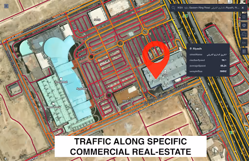
Traffic along specific Commercial Real Estate

Explore the influence of commercial real estate on traffic patterns. The content is crafted to educate users on identifying and understanding the interactions between commercial hubs and their surrounding traffic flows.
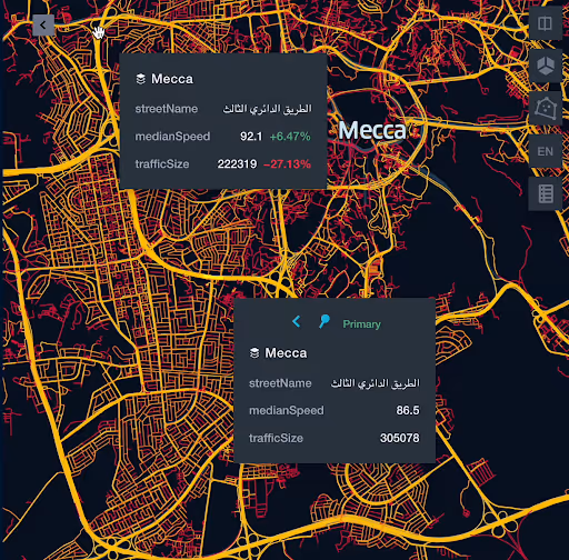
Median Speed Analysis in Mekkah

This analysis focuses on teaching the significance of median speed as an indicator of traffic efficiency in Mekkah. It guides users through interpreting this data to gauge congestion levels and overall traffic fluidity in the city.
Analysis of Saudi Arabia Restaurants POI with the Traffic on Roads
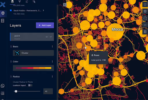
Users are instructed on how to correlate restaurant locations with traffic data, uncovering the impact of dining establishments on road congestion. The section is designed as a step-by-step guide to reveal underlying traffic trends influenced by restaurant POIs.
Commercial Real Estate Grids along with their Traffic Stats
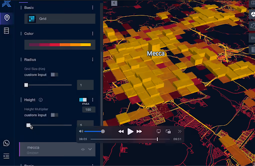
It serves for understanding the relationship between commercial real estate grids and traffic statistics. Users are guided through analyzing these data points to draw valuable insights for urban development and traffic management."
Traffic Roads connecting Mecca city with At Taif City
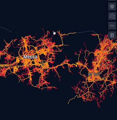
In this comprehensive map, users learn to analyze the traffic conditions on key routes between Mecca and At Taif. The content is structured to highlight congestion points, travel patterns, and route efficiency, providing a thorough understanding of intercity travel dynamics.
Why xMap?
xMap empowers businesses with unparalleled location intelligence and comprehensive data analysis, guiding them towards market leadership and growth.
Frequently Asked Questions
Find answers to commonly asked questions about our spatial analyst platform.
Data is updated monthly to provide the latest traffic insights.
Yes, it seamlessly integrates with most GIS platforms for comprehensive spatial analysis.
It would be deal for traffic analysis, median speed, trend analysis and forecasting.

