Romania - Road Traffic Data
Delve into the complexities of Romania's road networks with our comprehensive traffic dataset, offering critical insights into traffic flows, congestion levels, and vehicle distributions across diverse urban and rural landscapes. Ideal for government bodies, urban planners, and transport developers, this dataset is pivotal for formulating effective traffic management strategies, optimizing public transportation systems, and guiding sustainable infrastructure projects throughout Romania.
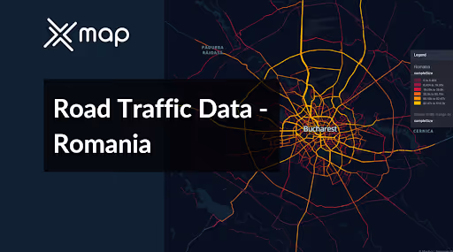


Vital Traffic Insights across the Romania
Analyze detailed data and research that offer valuable understanding of the intricacies of traffic flow, congested areas, and required speed adjustments for effective transportation planning in Romania.
Download a Sample
Preview the depth and breadth of our traffic data collection, showcasing how granular insights can revolutionize transportation planning and management in Romania.
.avif)
Key Variables
Analyze detailed data and research that offer valuable understanding of the intricacies of traffic flow, congested areas, and required speed adjustments for effective transportation planning in Romania.
Use Cases
How can this dataset benefit you?
Utilize Romania's road traffic data to develop and implement a smart traffic management system in Bucharest. This system can include adaptive traffic signals that respond to real-time traffic conditions, intelligent routing systems to alleviate congestion, and advanced analytics to predict traffic patterns. This will help reduce commute times, enhance traffic flow, and lower emissions in the capital.
Leverage the traffic and accident data to identify high-risk areas on Romania's national roads, such as those in mountainous regions like Transylvania. Use this information to prioritize road safety improvements, including better road markings, enhanced signage, and the installation of barriers to prevent accidents. Additionally, initiate targeted educational campaigns to raise awareness about safe driving practices in these high-risk zones.
Employ road traffic data to plan and enhance infrastructure in key tourist destinations, such as the Black Sea coast and the Danube Delta. Analyze traffic flows during peak tourist seasons to determine necessary upgrades for roads, the addition of parking facilities, and the improvement of public transport links. These measures aim to improve access to these areas, enhance the visitor experience, and support local economies.
Everything You need to know to know about the Road Traffic of Romania
Median Vehicle Speeds by Road Names
This analysis evaluates median vehicle speeds across various road types, highlighting efficiency and congestion levels from highways to local streets.
Speed Limit Distribution
Explores the range and prevalence of speed limits throughout Romania, identifying areas with strict regulations and potential zones for speed limit adjustments.

Functional Road Class (FRC) Distribution
Illustrates the variety of road types within the network, from major thoroughfares to local streets, and their distribution across the territory.

Average Speed by Functional Road Class (FRC)
Analyzes average speeds based on road functional classifications, providing insights into traffic flow and congestion differences between arterial roads and local streets.

Average Speed Distribution for Șoseaua Olteniței
Examines speed patterns along this major road, highlighting areas of congestion or high efficiency and their impact on travel times.

Bucharest Street Traffic Analysis
Presents a detailed examination of traffic flow on Bucharest’s streets, including peak traffic times, average speeds, and congested areas, supported by visual data.

Why xMap?
xMap empowers businesses with unparalleled location intelligence and comprehensive data analysis, guiding them towards market leadership and growth.
Frequently Asked Questions
Find answers to commonly asked questions about our spatial analyst platform.
This dataset encompasses real-time and historical data on traffic density, accidents, road conditions, and congestion trends.
Leverage this dataset for site selection, analyze road traffic on your desired business location, enhanced route planning, strategic urban development projects, and to implement proactive traffic management strategies.
At xMap, we are committed to ensuring that our clients can leverage our datasets effectively. We provide comprehensive technical support, including help with data integration, troubleshooting, and optimization of data use. Additionally, we offer consulting services to help businesses understand and analyze traffic data to meet their specific strategic objectives.

