Nigeria | Road Traffic Data
Dive deep into the complexities of Nigeria’s bustling road networks with our extensive traffic dataset, offering critical insights into traffic volumes, congestion patterns, and vehicle types across diverse regions from the congested streets of Lagos to the quieter roads of smaller towns. Ideal for policy makers, urban planners, and businesses, this dataset is invaluable for devising effective traffic management solutions, enhancing public transportation systems, and supporting infrastructure development initiatives across Nigeria.
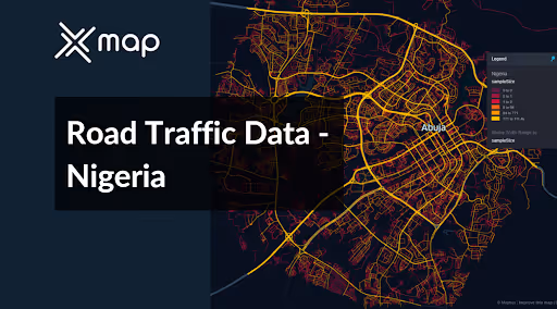


Vital Traffic Insights across the Nigeria
Examine in-depth data and studies that provide insight into the complexities of traffic patterns, heavily congested zones, and variations in velocity needed for making well-informed decisions when designing transportation infrastructure in Nigeria.
Download a Sample
Preview the depth and breadth of our traffic data collection, showcasing how granular insights can revolutionize transportation planning and management in Nigeria.
Key Variables
Examine in-depth data and studies that provide insight into the complexities of traffic patterns, heavily congested zones, and variations in velocity needed for making well-informed decisions when designing transportation infrastructure in Nigeria.
Use Cases
How can this dataset benefit you?
Utilize the road traffic data from Nigeria to develop and implement strategic traffic congestion management plans in Lagos, one of Africa's most congested cities. This includes optimizing traffic signal timings, planning for dedicated bus lanes, and implementing carpooling incentives during peak hours to alleviate traffic congestion and improve overall traffic flow.
Leverage traffic volume and pattern data to guide infrastructure development projects across Nigeria. Use this information to prioritize the construction of new roads, bridges, and underpasses in areas with heavy traffic, ensuring that these projects are aligned with actual traffic needs and can effectively reduce bottlenecks and improve connectivity.
Analyze traffic flow data to optimize Nigeria’s public transport system, particularly in urban areas. Determine the most crowded routes and times, and use this information to adjust public transport schedules, increase vehicle frequency, and introduce new routes where needed. This approach aims to make public transport a more attractive and efficient option for commuters, thus reducing reliance on private vehicles and alleviating road congestion.
Everything You need to know to know about the Road Traffic of Nigeria
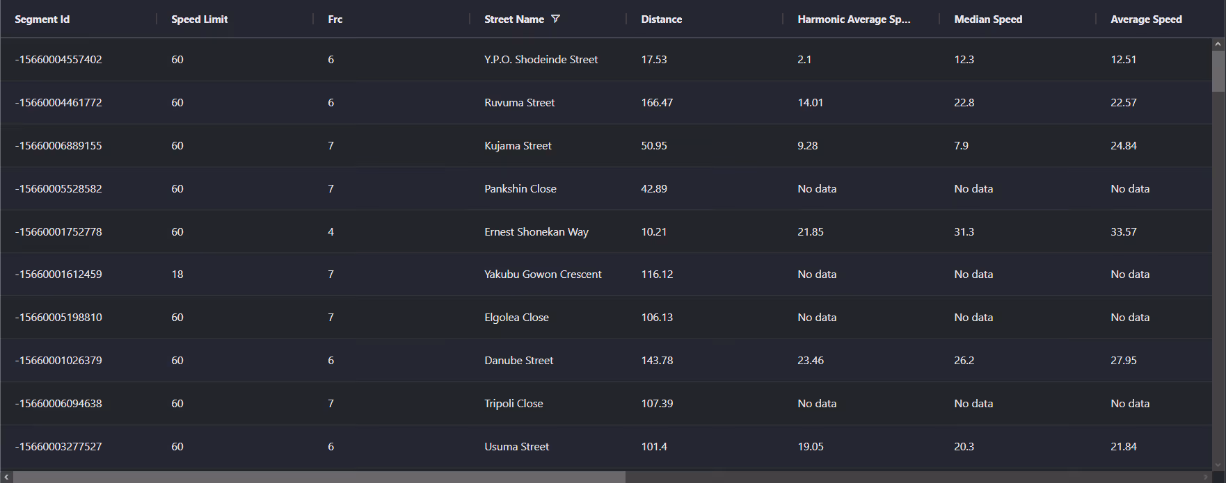
Median Vehicle Speeds by Road Names
This analysis evaluates the median vehicle speeds across various road names, shedding light on the efficiency and congestion levels from highways to local streets.
Speed Limit Distribution
This section explores the range and prevalence of speed limits throughout Nigeria, pinpointing areas with strict regulations and identifying potential zones for speed limit adjustments.

Functional Road Class (FRC) Distribution
This illustration details the variety of road types within the network, ranging from major thoroughfares to local streets, and shows their distribution across the territory.

Average Speed by Functional Road Class (FRC)
Analyzes average speeds according to functional road classifications, providing insights into traffic flow and congestion differences between arterial roads and local streets.

Average Speed Distribution for Ring Road
Examines speed patterns along this major road, highlighting areas of congestion or high efficiency and their impact on travel times.

Top 10 Streets by Average Speed
Lists the top 10 streets by average speed, offering an overview of traffic conditions in busy urban areas or on efficient routes.

Abuja Street Traffic Analysis
Presents a detailed examination of traffic flow on Abuja's streets, including peak traffic times, average speeds, and congested areas, supported by visual data.

Why xMap?
xMap empowers businesses with unparalleled location intelligence and comprehensive data analysis, guiding them towards market leadership and growth.
Frequently Asked Questions
Find answers to commonly asked questions about our spatial analyst platform.
This dataset encompasses real-time and historical data on traffic density, accidents, road conditions, and congestion trends.
Leverage this dataset for site selection, analyze road traffic on your desired business location, enhanced route planning, strategic urban development projects, and to implement proactive traffic management strategies.
At xMap, we are committed to ensuring that our clients can leverage our datasets effectively. We provide comprehensive technical support, including help with data integration, troubleshooting, and optimization of data use. Additionally, we offer consulting services to help businesses understand and analyze traffic data to meet their specific strategic objectives.

