Mexico - Road Traffic Data
Explore the dynamic flow of Mexico's roadways with our comprehensive traffic dataset, providing detailed insights into traffic patterns, congestion levels, and vehicle types across urban and rural areas. Ideal for government agencies, urban planners, and transportation companies, this dataset is crucial for crafting effective traffic management strategies, improving public transport systems, and planning sustainable infrastructure projects throughout Mexico.
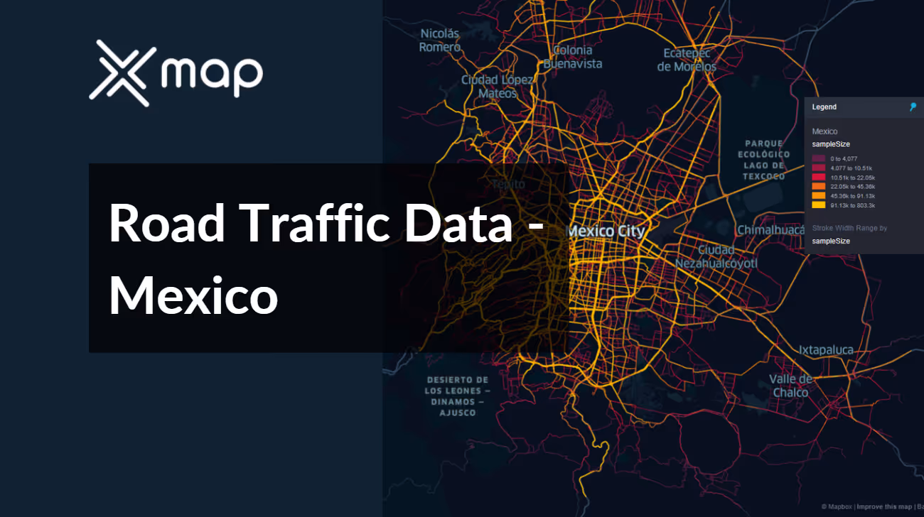


Vital Traffic Insights across the Mexico
Examine in-depth data and studies that emphasize the complexities of traffic flow, congested zones, and variations in speed—essential for making informed decisions in the coordination and organization of transportation throughout Mexico.
Download a Sample
Preview the depth and breadth of our traffic data collection, showcasing how granular insights can revolutionize transportation planning and management in Mexico.
.avif)
Key Variables
Examine in-depth data and studies that emphasize the complexities of traffic flow, congested zones, and variations in speed—essential for making informed decisions in the coordination and organization of transportation throughout Mexico.
Use Cases
How can this dataset benefit you?
Utilize Mexico's road traffic data to enhance urban mobility in major cities such as Mexico City, Monterrey, and Guadalajara. Implement data-driven strategies such as adaptive traffic signal systems, real-time traffic condition updates, and strategic public transit improvements to alleviate urban congestion and improve commute times.
Leverage traffic data to support eco-friendly transportation initiatives across Mexico. Use insights from the data to identify key areas for the expansion of bike lanes and pedestrian pathways, and to plan the deployment of electric bus routes. These measures aim to reduce carbon emissions, encourage healthier lifestyles, and decrease reliance on private vehicle usage.
Analyze traffic volume and accident data to prioritize road infrastructure development and maintenance projects. Focus on areas with high traffic loads and frequent accidents to improve road conditions, enhance safety, and facilitate smoother traffic flow. This targeted approach helps in optimizing resource allocation for road construction and maintenance, ensuring efficient use of public funds.
Everything You need to know to know about the Road Traffic of Mexico
Median Vehicle Speeds by Road Names
This analysis evaluates median vehicle speeds across different road types, highlighting efficiency and congestion levels from highways to local streets.
Speed Limit Distribution
Explores the range and prevalence of speed limits throughout Mexico, identifying areas with strict regulations and potential zones for speed limit adjustments.

Functional Road Class (FRC) Distribution
Illustrates the variety of road types within the network, from major thoroughfares to local streets, and their distribution across the territory.

Average Speed by Functional Road Class (FRC)
Analyzes average speeds based on road functional classifications, providing insights into traffic flow and congestion differences between arterial roads and local streets.

Average Speed Distribution for Avenida Central
Examines speed patterns along this major road, highlighting areas of congestion or high efficiency and their impact on travel times.

Top 10 Streets by Average Speed
Lists the top 10 streets by average speed, offering an overview of traffic conditions in busy urban areas or on efficient routes.

Mexico City Street Traffic Analysis
Presents a detailed examination of traffic flow on Mexico City's streets, including peak traffic times, average speeds, and congested areas, supported by visual data.

Why xMap?
xMap empowers businesses with unparalleled location intelligence and comprehensive data analysis, guiding them towards market leadership and growth.
Frequently Asked Questions
Find answers to commonly asked questions about our spatial analyst platform.
This dataset encompasses real-time and historical data on traffic density, accidents, road conditions, and congestion trends.
Leverage this dataset for site selection, analyze road traffic on your desired business location, enhanced route planning, strategic urban development projects, and to implement proactive traffic management strategies.
At xMap, we are committed to ensuring that our clients can leverage our datasets effectively. We provide comprehensive technical support, including help with data integration, troubleshooting, and optimization of data use. Additionally, we offer consulting services to help businesses understand and analyze traffic data to meet their specific strategic objectives.

