Iceland - Road Traffic Data
Explore a comprehensive data repository that uncovers the intricate dynamics of road usage, congestion, and traffic flow across Iceland. Gain valuable insights from this extensive dataset to guide your strategic decisions with a thorough understanding of the nation's traffic patterns.
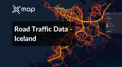


Vital Traffic Insights across the Iceland
Analyze detailed metrics and studies that reveal the complexities of traffic flow, congestion hotspots, and speed trends—crucial for informed transportation planning and management throughout Iceland.
Download a Sample
Preview the depth and breadth of our traffic data collection, showcasing how granular insights can revolutionize transportation planning and management in Iceland.
Key Variables
Analyze detailed metrics and studies that reveal the complexities of traffic flow, congestion hotspots, and speed trends—crucial for informed transportation planning and management throughout Iceland.
Use Cases
How can this dataset benefit you?
Use Iceland's road traffic data to manage and optimize the flow of tourist vehicles in sensitive natural reserves and popular destinations such as the Golden Circle. Implement timed entry systems and real-time traffic monitoring to prevent overcrowding and minimize environmental impact, ensuring sustainable tourism practices.
Leverage traffic and weather data to enhance road safety during Iceland’s harsh winter months. Prioritize snow removal and de-icing efforts based on traffic flow data, focusing on key routes used for commuting and tourism. This approach ensures safer travel during snowstorms and icy conditions, reducing the risk of accidents.
Utilize the road traffic data to improve logistics and supply chain efficiency in Iceland. Analyze traffic patterns to determine optimal delivery times and routes, particularly for remote areas. This information helps logistics companies to avoid congestion and delays, thereby improving delivery efficiency and customer satisfaction.
Everything You need to know to know about the Road Traffic of Iceland
Median Vehicle Speeds by Road Names
This analysis examines the median speeds of vehicles across different road types, highlighting efficiency and congestion levels from highways to local streets.
Speed Limit Distribution
Explores the range and prevalence of speed limits throughout Iceland, identifying areas with strict regulations and potential zones for speed limit adjustments.

Functional Road Class (FRC) Distribution
Displays the variety of road types within the network, from major thoroughfares to local streets, and their distribution across the territory.

Average Speed by Functional Road Class (FRC)
Evaluates average speeds based on road functional classifications, providing insights into traffic flow and congestion differences between arterial roads and local streets.

Average Speed Distribution for Reykjanesbraut
Analyzes speed patterns along this major road, highlighting areas of congestion or high efficiency and their impact on travel times.

Top 10 Streets by Average Speed
Lists the top 10 streets by average speed, offering an overview of traffic conditions in busy urban areas or on efficient routes.

Reykjavík Street Traffic Analysis
Provides a detailed examination of traffic flow on Reykjavík's streets, including peak traffic times, average speeds, and congested areas, supported by visual data

Why xMap?
xMap empowers businesses with unparalleled location intelligence and comprehensive data analysis, guiding them towards market leadership and growth.
Frequently Asked Questions
Find answers to commonly asked questions about our spatial analyst platform.
This dataset encompasses real-time and historical data on traffic density, accidents, road conditions, and congestion trends.
This dataset is invaluable for urban planners, infrastructure developers, environmental policy makers, and businesses involved in logistics and transportation. It supports strategic decision-making to optimize traffic flow, enhance infrastructure, and develop policies aimed at reducing environmental impacts.
At xMap, we are committed to ensuring that our clients can leverage our datasets effectively. We provide comprehensive technical support, including help with data integration, troubleshooting, and optimization of data use. Additionally, we offer consulting services to help businesses understand and analyze traffic data to meet their specific strategic objectives.

