Finland - Road Traffic Data
Delve into an extensive data repository that uncovers the complex dynamics of road usage, congestion, and traffic flow across Finland. Gain valuable insights from this comprehensive dataset to inform your strategic decisions with a thorough understanding of the nation's traffic patterns.


Vital Traffic Insights across the Finland
Examine detailed metrics and analyses that reveal the intricacies of traffic flow, congestion hotspots, and speed trends—essential for informed transportation planning and management throughout Finland.
Download a Sample
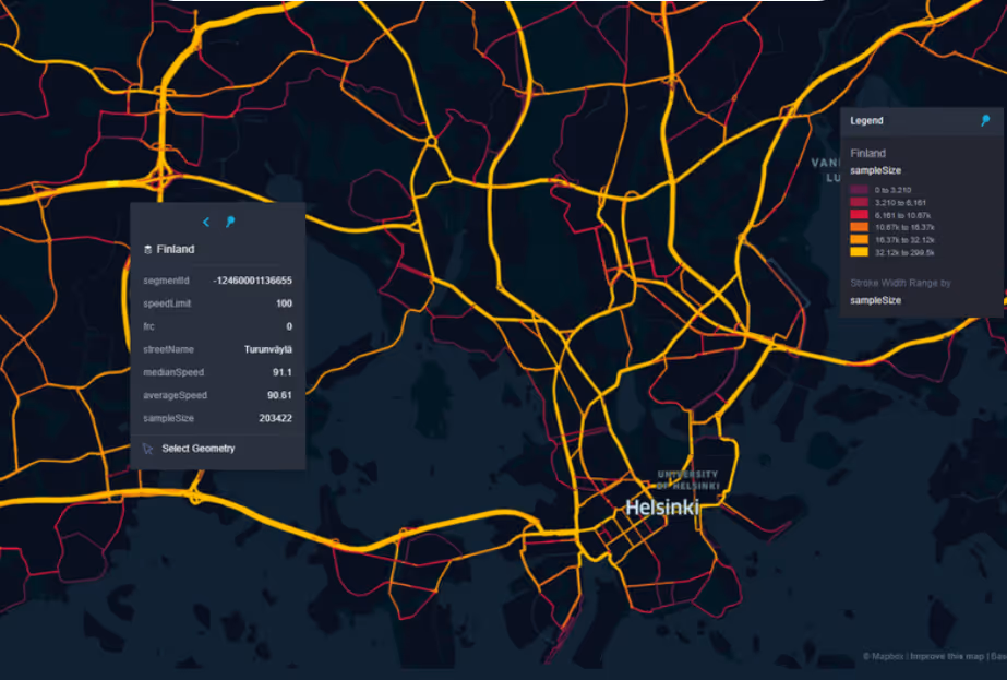
Preview the depth and breadth of our traffic data collection, showcasing how granular insights can revolutionize transportation planning and management in Finland.
.avif)
Key Variables
Examine detailed metrics and analyses that reveal the intricacies of traffic flow, congestion hotspots, and speed trends—essential for informed transportation planning and management throughout Finland.
Use Cases
How can this dataset benefit you?
Leverage Finland’s road traffic data to develop optimized routing algorithms for emergency services such as ambulances and fire trucks. By analyzing real-time traffic conditions and historical data, these algorithms can suggest the fastest and safest routes to emergency scenes, potentially saving lives by reducing response times.
Use traffic data to facilitate the integration of autonomous vehicles in Finland, particularly in testing their adaptability to various traffic conditions and environments. Traffic data can help in simulating real-world scenarios for autonomous vehicles, ensuring they are well-prepared to handle urban and rural traffic before widespread deployment.
Employ traffic data to support eco-friendly city planning initiatives, such as the creation of low-emission zones and the expansion of bike lanes. By understanding traffic flow patterns and peak congestion areas, city planners can implement targeted measures that encourage public and non-motorized transport, reducing carbon emissions and improving air quality in urban centers.
Everything You need to know to know about the Road Traffic of Finland
Median Vehicle Speeds by Road Names
This analysis examines the median speeds of vehicles across different road types, highlighting efficiency and congestion levels from highways to local streets.
Speed Limit Distribution
Investigates the range and prevalence of speed limits throughout Finland, pinpointing areas with strict regulations and potential zones for speed limit adjustments.

Functional Road Class (FRC) Distribution
Illustrates the diversity of road types within the network, from major thoroughfares to local streets, and their distribution across the country.

Average Speed by Functional Road Class (FRC)
Analyzes average speeds based on road functional classifications, providing insights into traffic flow and congestion differences between arterial roads and local streets.

Average Speed Distribution for Kehä III
Focuses on speed patterns along this major road, highlighting areas of congestion or high efficiency and their impact on travel times.

Top 10 Streets by Average Speed
Lists the top 10 streets by average speed, offering an overview of traffic conditions in busy urban areas or on efficient routes.

Helsinki Street Traffic Analysis
Provides a detailed examination of traffic flow on Helsinki's streets, including peak traffic times, average speeds, and congested areas, presented with visual data.

Why xMap?
xMap empowers businesses with unparalleled location intelligence and comprehensive data analysis, guiding them towards market leadership and growth.
Frequently Asked Questions
Find answers to commonly asked questions about our spatial analyst platform.
This dataset encompasses real-time and historical data on traffic density, accidents, road conditions, and congestion trends.
This dataset is invaluable for urban planners, infrastructure developers, environmental policy makers, and businesses involved in logistics and transportation. It supports strategic decision-making to optimize traffic flow, enhance infrastructure, and develop policies aimed at reducing environmental impacts.
At xMap, we are committed to ensuring that our clients can leverage our datasets effectively. We provide comprehensive technical support, including help with data integration, troubleshooting, and optimization of data use. Additionally, we offer consulting services to help businesses understand and analyze traffic data to meet their specific strategic objectives.

