Chile - Road Traffic Data
Access a detailed dataset that uncovers the complex dynamics of road usage, congestion, and traffic flow across Chile. Leverage these valuable insights to guide your strategic decisions with a thorough understanding of the nation's traffic patterns.
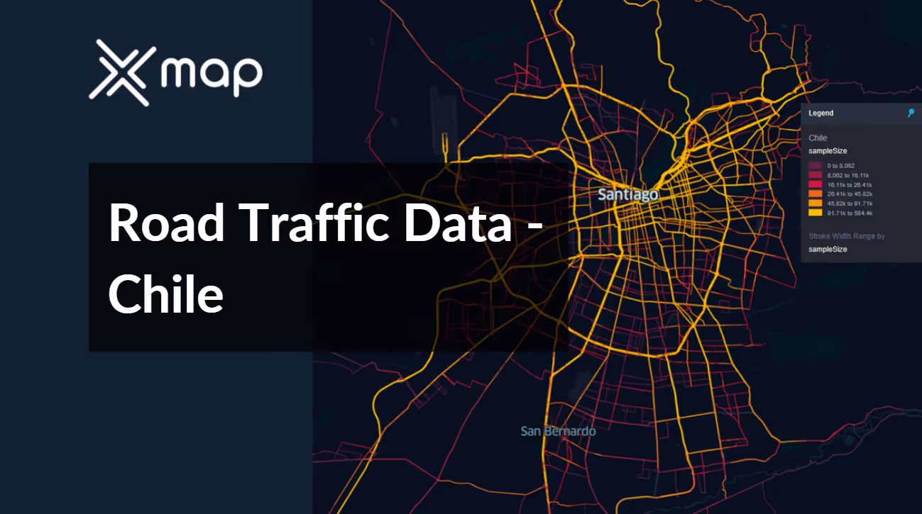


Vital Traffic Insights across the Chile
Uncover detailed metrics and analyses that reveal the nuances of traffic flow, congestion hotspots, and speed trends—crucial for informed transportation planning and management throughout Chile.
Download a Sample
Preview the depth and breadth of our traffic data collection, showcasing how granular insights can revolutionize transportation planning and management in Chile.
.avif)
Key Variables
Uncover detailed metrics and analyses that reveal the nuances of traffic flow, congestion hotspots, and speed trends—crucial for informed transportation planning and management throughout Chile.
Use Cases
How can this dataset benefit you?
Utilize Chile’s road traffic data to enhance disaster response strategies, particularly in earthquake-prone areas. Use traffic flow analytics to develop efficient evacuation routes and plans, ensuring rapid and safe movement of populations in times of natural disasters. This proactive approach can significantly reduce chaos and save lives during critical situations.
Utilize traffic data to improve public transit systems in major Chilean cities, such as Santiago and Valparaíso. Analyze congestion patterns and peak usage times to optimize bus routes, frequencies, and transit operations. This strategic use of data can increase public transit efficiency, encourage usage, and reduce overall urban congestion.
Use traffic data to conduct environmental impact studies, particularly focusing on air quality in densely populated areas. By identifying high-traffic zones and peak traffic hours, implement targeted policies such as alternate-day travel restrictions or incentives for electric vehicle usage to reduce pollution levels and promote sustainable urban environments.
Everything You need to know to know about the Road Traffic of Chile
Median Vehicle Speeds by Road Names
This analysis delves into the median speeds of vehicles across various road types, highlighting the efficiency and congestion levels ranging from highways to local streets.
Speed Limit Distribution
Examines the range and prevalence of speed limits throughout Chile, pinpointing areas with stringent regulations and potential zones for speed limit adjustments.

Functional Road Class (FRC) Distribution
Illustrates the variety of road classifications within the network, spanning from major thoroughfares to local streets, and their geographical distribution across the nation.

Average Speeds by Functional Road Class (FRC)
Dissects average speeds based on road functional classifications, providing insights into traffic flow and congestion disparities between arterial roads and local streets.

Average Speed Distribution for Avenida Américo Vespucio
Zooms in on speed patterns along this major road, showcasing congested areas or efficient stretches and their impact on travel durations.

Top 10 Streets by Average Speed
Enumerates the top 10 streets in terms of average speed, offering a snapshot of traffic conditions in bustling urban areas or highly efficient routes.

Traffic Analysis of Santiago's Streets
Offers a comprehensive examination of traffic flow in Santiago, encompassing peak traffic times, average speeds, and congested areas, accompanied by visual data.

Why xMap?
xMap empowers businesses with unparalleled location intelligence and comprehensive data analysis, guiding them towards market leadership and growth.
Frequently Asked Questions
Find answers to commonly asked questions about our spatial analyst platform.
This dataset encompasses real-time and historical data on traffic density, accidents, road conditions, and congestion trends.
Leverage this dataset for site selection, analyze road traffic on your desired business location, enhanced route planning, strategic urban development projects, and to implement proactive traffic management strategies.
At xMap, we are committed to ensuring that our clients can leverage our datasets effectively. We provide comprehensive technical support, including help with data integration, troubleshooting, and optimization of data use. Additionally, we offer consulting services to help businesses understand and analyze traffic data to meet their specific strategic objectives.

