Austria - Road Traffic Data
Explore a remarkable repository of data that uncovers the intricate dynamics of road usage, congestion, and traffic flow across Austria. Gain invaluable insights from this extensive dataset to guide your strategic decisions with a clear understanding of the nation's traffic patterns.
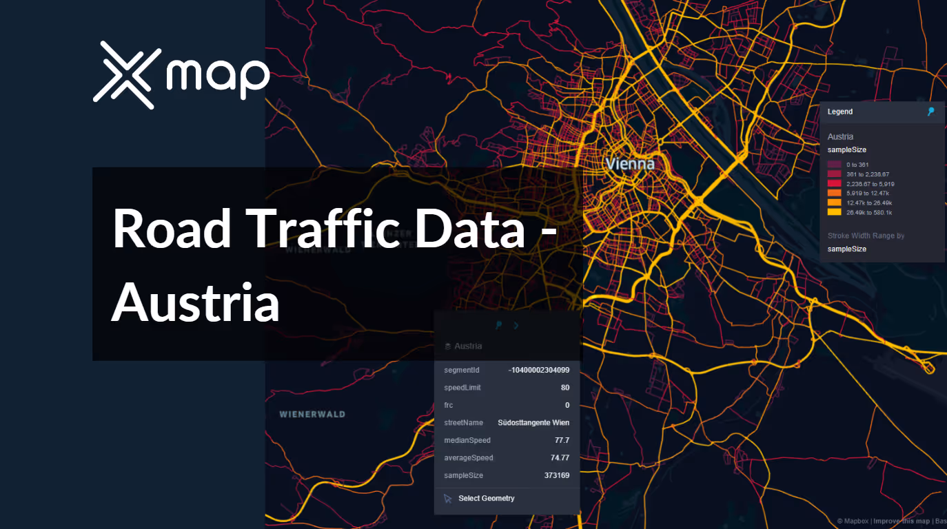


Vital Traffic Insights across the Austria
Discover detailed metrics and analyses that reveal the nuances of traffic flow, congestion hotspots, and speed trends—essential for informed transportation planning and management throughout Austria.
Download a Sample
Preview the depth and breadth of our traffic data collection, showcasing how granular insights can revolutionize transportation planning and management in Austria.
.avif)
Key Variables
Discover detailed metrics and analyses that reveal the nuances of traffic flow, congestion hotspots, and speed trends—essential for informed transportation planning and management throughout Austria.
Use Cases
How can this dataset benefit you?
Use data on the road traffic of Austria to improve traffic management during winter months in Alpine areas prone to heavy snowfall and tourist influx. Implement predictive analytics to anticipate traffic increases and optimize snow removal schedules and routes to maintain clear, safe driving conditions.
Analyze the road traffic data of Austria to identify regions where public transport could be enhanced to reduce private vehicle use. This data can assist in planning more efficient bus routes, schedules, and the placement of new tram or metro lines to meet commuter needs effectively.
Utilize the road traffic data from Austria to design eco-friendly tourism policies. By understanding traffic flow to popular tourist destinations, develop initiatives such as timed entry permits or shuttle services to limit the number of vehicles, reducing environmental impact and promoting sustainable tourism practices.
Everything You need to know to know about the Road Traffic of Austria
Median Speed by Street Names
This analysis explores the median vehicle speeds across various road types, highlighting efficiency and congestion levels from highways to local streets.
Distribution of Speed Limits
Analyzes the range and prevalence of speed limits across Austria, identifying zones of strict regulation and potential areas for speed limit adjustments.

Distribution of Functional Road Classes (FRC)
Highlights the diversity of road types within the network, from major roads to local roads, and their distribution across the country.

Average Speed by Functional Road Class (FRC)
Breaks down average speeds by road functional classification, offering insights into traffic flow and congestion on arterial roads compared to local roads.

Average Speed Distribution for West Autobahn
Focuses on speed patterns along this major road, showcasing areas of congestion or high efficiency and their impact on travel times.

Average Speed by Street Name (Top 10 streets)
Lists the top 10 streets in terms of average speed, offering a snapshot of traffic conditions in busy urban areas or efficient thoroughfares.

Vienna Street Road Traffic
Presents a detailed analysis of Vienna's traffic flow, including peak times, average speeds, and congestion points, illustrated with visual data.

Why xMap?
xMap empowers businesses with unparalleled location intelligence and comprehensive data analysis, guiding them towards market leadership and growth.
Frequently Asked Questions
Find answers to commonly asked questions about our spatial analyst platform.
The Austria Road Traffic dataset encompasses detailed metrics such as vehicle counts, types, speed, congestion levels, and time-stamped traffic flow patterns across various routes. This data is crucial for analyzing peak traffic times and identifying key congestion points.
Yes, the dataset includes both current and historical traffic data, allowing for comprehensive trend analysis over time. Users can assess seasonal variations, the impact of specific events on traffic, and long-term changes in traffic patterns to better understand and predict future traffic behaviors.
Businesses, particularly those in logistics, delivery services, and retail, can use the Austria Road Traffic dataset to optimize routing and delivery schedules, reduce travel times, and enhance fuel efficiency. By understanding traffic patterns, businesses can plan operations to avoid heavy traffic periods, thereby improving service efficiency and customer satisfaction.

