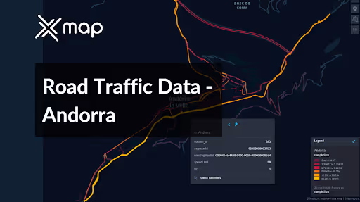
Andorra - Road Traffic Data
Delve into an extraordinary repository of data revealing the nuanced dynamics of road usage, congestion, and traffic flow throughout Andorra. Equip yourself with invaluable insights derived from this comprehensive dataset, guiding your strategic maneuvers with a clear understanding of the nation's vehicular heartbeat.


Vital Traffic Insights across the Andorra
Explore detailed metrics and analyses that uncover the nuances of traffic flow, congestion hotspots, and speed trends—vital for informed transportation planning and management across Andorra.
Download a Sample
Preview the depth and breadth of our traffic data collection, showcasing how granular insights can revolutionize transportation planning and management in Andorra.
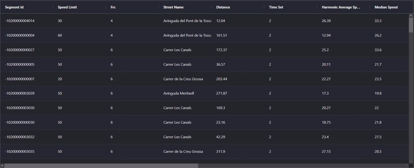
Key Variables
Explore detailed metrics and analyses that uncover the nuances of traffic flow, congestion hotspots, and speed trends—vital for informed transportation planning and management across Andorra.
Use Cases
How can this dataset benefit you?
Utilize real-time and historical data on the road traffic of Andorra to manage and alleviate congestion effectively. Implement dynamic traffic management systems to enhance road safety and the overall travel experience within the country.
Leverage trends from the road traffic data of Andorra to inform strategic infrastructure development. This approach helps in identifying high-demand areas for targeted road expansions or new constructions, optimizing public spending and supporting sustainable growth.
Use road traffic data from Andorra to formulate and assess environmental policies aimed at reducing vehicular impact on the natural landscape. Design restrictions and incentives to promote electric vehicle usage and improve public transportation, thereby enhancing air quality and protecting ecological zones.
Everything You need to know to know about the Road Traffic of Andorra
Median Speed by Street Names
This insight examines the median speed of vehicles maintained across different road types, highlighting efficiency and congestion levels from highways to local streets.
Distribution of Speed Limits
Analyses the range and commonality of speed limits across Andorra, indicating zones of high regulation and potential areas for speed limit adjustments.

Distribution of Functional Road Classes (FRC)
Highlights the diversity of road types within the network, from major roads to local roads, and their distribution across the country.

Average Speed by Functional Road Class (FRC)
Breaks down average speeds according to the road's functional classification, providing insights into traffic flow and congestion on arterial roads versus local roads.

Average Speed Distribution by Avinguda de Salou
Focuses on speed patterns along this major road, showcasing areas of congestion or high efficiency and their impact on travel times.

Average Speed by Street Name (Top 10 streets)
Lists the top 10 streets in terms of average speed, offering a snapshot of traffic conditions in busy urban areas or efficient thoroughfares.

Andorra la Vella Street Road Traffic
Presents a detailed traffic flow analysis of Andorra la Vella, including peak times, average speeds, and congestion points, using visual data.

Why xMap?
xMap empowers businesses with unparalleled location intelligence and comprehensive data analysis, guiding them towards market leadership and growth.
Frequently Asked Questions
Find answers to commonly asked questions about our spatial analyst platform.
The Andorra Road Traffic dataset includes a variety of information such as historical traffic data, congestion levels, traffic flow patterns, and types of vehicles on the roads. This data helps in understanding traffic dynamics and planning accordingly.
The dataset is updated periodically to ensure that users have access to the most current information. Real-time data is refreshed every few minutes, while historical data compilations are updated on a monthly basis to reflect new trends and patterns.
This dataset is invaluable for urban planners, infrastructure developers, environmental policy makers, and businesses involved in logistics and transportation. It supports strategic decision-making to optimize traffic flow, enhance infrastructure, and develop policies aimed at reducing environmental impacts.

