Singapore Road Traffic in 2024 - Everything You need to know
Welcome to the center of Singapore's urban scenery, where the beat of everyday life is determined by the flow of road traffic. In this busy city-state, known for its mix of modern and traditional elements, the flow of vehicles acts as a crucial link connecting different areas, businesses, and communities. Understanding the complexities of road traffic in Singapore, where space is constrained and population density is high, is crucial to improving transport infrastructure and enhancing daily commuting experiences. This article delves into data-driven insights That uncover patterns and trends affecting transportation in Singapore, offering valuable views for travelers, policymakers, and city planners. Join us as we delve into the intricacies of Singapore's traffic patterns on our journey towards a more efficient and interconnected future.
Average speed is a crucial measurement that shows the arithmetic mean of speed data recorded on a specific section of road. This parameter gives information on how well the road network is working by giving an overview of the general traffic flow. Observing the continuous changes in average speeds over time evaluates the effectiveness of different traffic management interventions. Furthermore, transportation authorities can easily identify congestion areas by analyzing average speed across different road segments and come up with better strategies to alleviate traffic bottlenecks.

This analysis of Average Speed Duration for Lebuhraya Laluan Ke II provides a nuanced understanding of speed fluctuations across various timescales, facilitating informed decision-making to optimize traffic management and alleviate congestion along this pivotal expressway in Singapore.
Integral to route planning and travel time estimations, the distance parameter quantifies the length of a road segment or route. Armed with precise distance data, commuters can make informed decisions regarding their travel routes, optimizing journey durations and minimizing congestion-induced delays. Additionally, distance measurements serve as the foundation for various transportation models, facilitating scenario analysis and infrastructure planning. Notably, Singapore's Lebuhraya Laluan Ke II, spanning 110,983.66 meters, stands as a testament to the diverse range of distances encompassed within the nation's road network.
Speed limit denoting the maximum legally permissible speed on a given road segment. Set with safety considerations in mind, speed limits play a crucial role in mitigating accidents and ensuring smooth traffic flow. By comparing actual speeds with the prescribed limits, authorities can pinpoint areas of non-compliance and enforce necessary measures to enhance road safety. Furthermore, incorporating speed limit data into traffic flow analysis facilitates the identification of stretches where adjustments may be needed to optimize vehicular movement.

This part of the analysis examines the distribution of speed limits across Singapore, providing valuable insights into the regulatory framework governing vehicle speeds. Analyzing this distribution is crucial to measure compliance with speed regulations, evaluate the effectiveness of current speed limits, and develop strategies to enhance road safety measures.
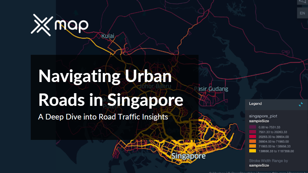
Exploring Singapore's traffic landscape through data visualization offers a concise yet powerful means to comprehend complex mobility patterns. By harnessing the visual medium, we unveil key insights into traffic flows, congestion points, and transportation trends, empowering stakeholders with actionable intelligence to enhance Singapore's road network efficiency and safety.
The road traffic data in Singapore offers a detailed overview of the city-state's transportation system, including important measurements like vehicle speeds, compliance with speed limits, and levels of congestion on both urban and suburban roads. It is important to highlight that 81.83% of road sections demonstrate impressive adherence to set speed limits, proving the efficacy of regulatory actions. This data set offers valuable information to transportation planners and policymakers, helping them enhance traffic management, improve road safety, and ensure effective mobility for both residents and visitors.
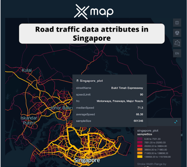

Singapore's road network presents a diverse distribution of Functional Road Class (FRC), providing essential insights into transportation infrastructure. With nearly 20,000 Secondary Roads, the city ensures robust urban mobility and accessibility. Exceeding 15,000, Local Roads and Local Connection Roads serve as vital arteries for neighborhood connectivity and localized travel. Around 13,000 Major Roads ,less important than Motorways, play a significant role in regional transportation. Notably, Motorways and Freeways, totaling approximately 6,000, offer specialized routes for high-speed and uninterrupted travel. Understanding this distribution is paramount for urban planners and policymakers, guiding strategic decisions to optimize traffic flow, prioritize infrastructure development, and enhance overall transportation efficiency in Singapore.
Examining average speeds by road categories reveals interesting insights into the diverse traffic dynamics that occur across different types of roads in Singapore. From busy urban streets like Jalan Tengku Azizah and Jalan Sawmill, where average speeds hover around the low 20s, indicative of slow city driving, to arterial roads like Causeway and Jalan Perindustrian that have average speeds in the low 30s, indicative of smoother traffic flow. However, the data escalates dramatically for highways and expressways, with Lebuhraya Laluan Kidua Malaysia-Singapore and Lebuhraya Utara Selatan recording average speeds exceeding 90 km/h, emblematic of the rapid transit these major roads facilitate. This gradation of average speeds across road classes underscores the nuanced nature of Singapore's road network and underscores the importance of traffic management strategies tailored to each road class.

Examining the Average Speed by Functional Road Class (FRC) in Singapore offers insights into the diverse characteristics and traffic dynamics across different types of roadways. Local Roads, crucial for neighborhood connectivity, maintain an average speed of approximately 40 km/h, reflecting their role in facilitating local travel and access. In contrast, Major Roads, albeit less significant than Motorways and Freeways, exhibit speeds exceeding 60 km/h, underscoring their importance in regional transportation networks. Meanwhile, Other Major Roads and Secondary Major Roads, with similar average speeds of around 40 km/h, serve as essential arteries in the urban infrastructure, balancing efficiency with accessibility. This analysis highlights the varying roles and functionalities of different road classes, emphasizing the need for tailored traffic management strategies to optimize mobility and ensure smooth transportation flow throughout Singapore.

Examining the average speed per street name, specifically the top 10 streets in Singapore, offers valuable information on the effectiveness and movement of traffic on main roads throughout the country. Although the majority of streets have a typical average speed of about 60 km/h, some roads like Lebuhraya Sultan Iskandar have average speeds over 80 km/h, while Upper Serangoon Road averages around 40 km/h, showing differences in traffic flow and road conditions. This distribution of average speeds underscores the diverse nature of Singapore's road network and underscores the importance of considering factors like road classification and purpose in strategic planning, maintenance prioritization, and traffic optimization efforts. Such insights enable authorities to allocate resources effectively, implement targeted interventions, and ensure smooth traffic flow across different road types, ultimately enhancing overall transportation efficiency and commuter experience in Singapore.
Authorities can utilize real-time traffic data analysis to identify congested areas, monitor traffic trends, and implement changes to enhance traffic flow, like adjusting signal timing or overseeing lanes.
Information from road traffic assists in comprehending patterns of travel demand, such as peak travel periods and common travel routes. This data aids in creating travel demand management strategies like encouraging traveling during non-peak hours, supporting telecommuting, and introducing congestion pricing to reduce traffic congestion at peak times.
Examining road traffic data allows for the identification of high-risk areas and causes of accidents, including speeding and irresponsible driving. This data guides the execution of focused road safety campaigns, enforcement actions, and infrastructure enhancements to lower accident rates and enhance road safety for all individuals using the road.
Analyzing road traffic data is crucial in evaluating how transportation activities, such as vehicle emissions and noise pollution, affect the environment. Authorities can create plans to reduce environmental effects by studying traffic flow and vehicle behavior, like encouraging electric car usage or launching eco-friendly transportation projects.
The wealth of information within Singapore's Road Traffic Data offers invaluable perspectives on urban mobility, encompassing average speeds, congestion metrics, and road categorizations. Armed with these insights, stakeholders possess the tools to refine traffic strategies, elevate safety measures, and elevate overall transportation effectiveness. Whether it's urban planners crafting city layouts, policymakers shaping regulations, or commuters planning routes, harnessing this data becomes pivotal in navigating Singapore's thoroughfares adeptly and fostering a sustainable transport framework.
Visual Representation: xMap uses advanced visualization techniques to present Singapore road traffic data in intuitive maps, charts, and graphs. This aids businesses in quickly understanding traffic patterns and congestion areas, facilitating easy identification of areas for improvement and logistics optimization.
Comprehensive Data Analysis: Leveraging xMap's robust analytical capabilities, businesses can delve into factors such as street names, speed limits, and median speeds. This analysis offers a deep understanding of traffic dynamics, enabling informed decisions to optimize routes and enhance customer service.
Updated Data: xMap ensures businesses have access to up-to-date Singapore road traffic data, allowing them to monitor current conditions and plan operations effectively. Timely insights help businesses adapt to changing traffic patterns and optimize resource allocation.
Customized Insights: xMap offers customizable features for tailored analysis to specific needs. Whether focusing on a region, time frame, or traffic parameter, this flexibility allows businesses to extract actionable insights aligned with their goals.
User-friendly Interface: With xMap's intuitive interface, all team members can easily engage with and analyze traffic data. This promotes collaboration, informed decision-making, and increased operational efficiency.
To get all the details about Singapore Traffic data, See this dataset page.
Or visit our catalog page.
If you’d like to data samples for other countries like Egypt, USA, Switzerland, Japan, Turkey, UAE, and others, please visit our platform and sign up.
This data is provided by LocationMind but the data source is TomTom


Whatever your goal or project size, we will handle it.
We will ensure you 100% satisfication.
"We focus on delivering quality data tailored to businesses needs in the middle east. Whether you are a restaurant, a hotel, or even a gym, you can empower your operations' decisions with geo-data.”


